

Feature
The Summerland trailhead is closed through 2029 while the park replaces a 1931 bridge built with both feet in Fryingpan Creek
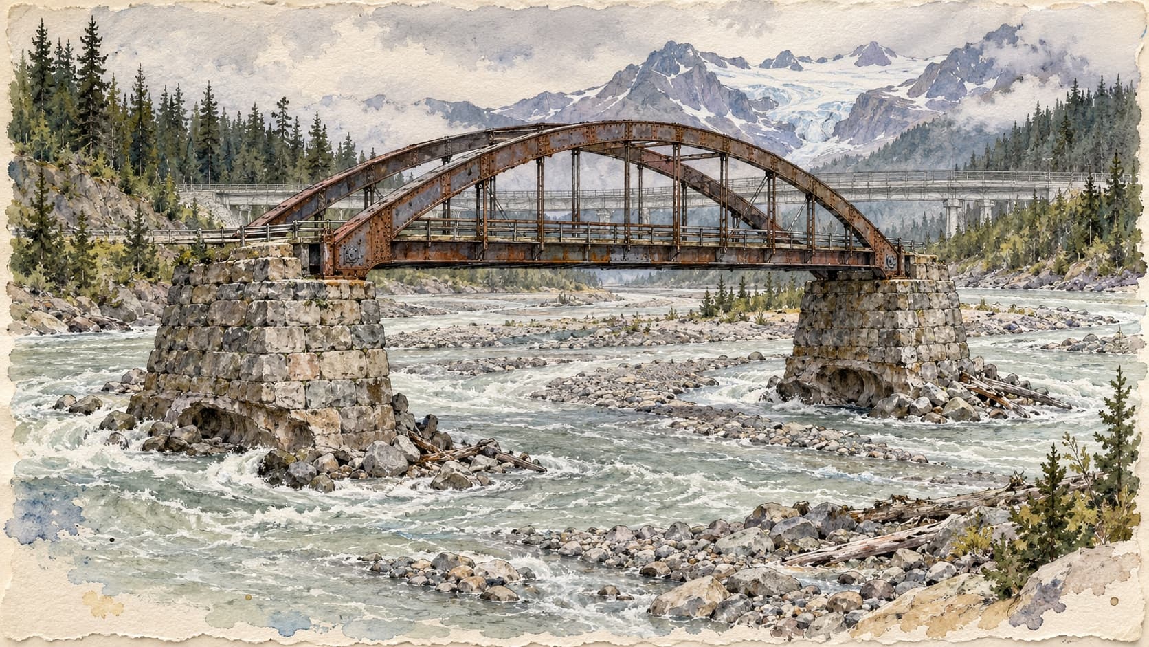
Why Mount Rainier's Summerland trailhead is closed through 2029: a 1931 bridge with its feet in Fryingpan Creek, the longer hike in, and the road delays.
In the last days of September crews went to work at the Fryingpan Creek Bridge, three miles past the White River entrance to Mount Rainier National Park. The Park Service's news release dates the start to Monday, September 28, and its construction page to a day earlier. The first job is cutting trees. The parking lot at the west end of the bridge, fifteen pull-in spaces and room for about ten more cars on the shoulder, is closed, and the Park Service says it will stay closed until the project is done, which it expects by late fall 2029. That lot is the Summerland trailhead, the start of what the park calls one of its most crowded trails.
The easy guess is the story this site told about the Carbon River Road, where a glacier filled its river with rubble until the bed had risen as much as 31 feet and the water climbed over the road. Fryingpan Creek comes off a glacier too. But the park's 2023 environmental assessment says of this spot that "there is currently no evidence of meaningful aggradation from Fryingpan Creek," aggradation being the geologists' word for a riverbed building itself up. On that evidence the creek never came up to meet the bridge. The bridge was built standing in the creek, and the creek has spent 95 years working on its feet.
A crossing longer than the creek seemed to need
The road is the old Yakima Park Highway, built between 1927 and 1931 under the federal Bureau of Public Roads to reach Sunrise. The lower stretch is now White River Road. Its engineers knew what they were crossing. A 1992 history of the bridge by the Historic American Engineering Record, drawing on the builders' reports, says that "park records indicate that the stream has changed channels three times in one 24-hour period." The location survey, as the record summarizes it, judged the best available crossing "considerably longer than might be expected for a stream of such size," with a west bank open to erosion.
Money shaped the rest. In April 1928 Thomas Vint, the Park Service's chief landscape engineer, ordered bare concrete instead of stone-faced concrete, to save an estimated $15,000. By March 1930 the Bureau had another answer: a steel arch 128 feet across, hinged at each end and at the crown, springing from stone-faced abutments, the masonry blocks that carry a bridge's ends. The record calls it "the only historic exposed steel bridge in the park."
Albert F. Berni of Portland won the job in July 1930 with a low bid of $54,259.20. He strung an aerial tram over the creek and flew his equipment across on it, trucks and concrete mixers included. His crew dug 10 to 14 feet below the stream bed for the footings, quit for the winter on November 12, and came back on July 7, 1931. The Department of the Interior accepted the bridge on September 21, 1931, eight days after the Chinook Pass highway got its mock wedding at Tipsoo Lake, another story this site has told.
As for the name, Edmond Meany's 1916 list of park place names records "two conflicting theories": that campers lost a frying pan in the stream, or that Professor I. C. Russell thought the glacier looked like one. Meany did not pick. The Park Service spells it as one word; the 1930 construction drawings used two.
What ninety years did
In 1963 a federal inspector found alkali damage in the concrete. He also noted, the engineering record says, that material had washed out from the base of the east abutment, but he recommended no rock armor, known as riprap, because "the bridge had been designed with an adequate footing."
The bridge was built for a 75-year service life, which ran out in 2006, and for a two-axle, 15-ton truck. The Federal Highway Administration's 2020 inspection, quoted in the park's assessment, rated it "seriously deficient or presents a safety hazard but can remain open at reduced loads or with frequent inspections." The underside of the deck is cracked, with rebar showing. The lead-based paint is failing and dropping into the creek, and the steel beneath it is rusting. The abutments, the east one especially, "are eroding due to their location in the creek channel." Both are undermined.
The bridge is safe to drive for now, the assessment says. What worried the park was the next step: load limits that would turn back fire engines and snowplows, and after that a failure that would cut the only road to White River Campground and Sunrise, the second busiest area in the park. By the assessment's table, the entrance station counts about 51,000 vehicles in an average July.
Why this is not the Carbon River
The assessment lays out the park-wide problem plainly: glaciers melting, riverbeds filling with rock, floods overtopping banks. It names the Carbon, where in places the flow "is now higher than the historic road." Then it makes an exception. "Fryingpan Creek has a glacial source," it says, "but the Fryingpan Glacier starts lower on the mountain." It does not say why a lower glacier should spare a creek bed. What it reports is the result at this spot.
What this creek does is move sideways. The bridge sits at the top of an alluvial fan, about 2,200 feet upstream of the White River, where the creek spreads into several channels across its own gravel. Both abutments stand inside the 100-year floodplain and pinch it. A Park Service brochure on the park's bridges says the steel arch was "designed for this frequently shifting stream." The stream kept shifting. The abutments could not.
One page of the park's website is looser, saying only that "the riverbed has changed," without saying how. The assessment is the fuller document, though its sentence on aggradation cites only the park's general web page on the subject. What it worries about for the future is flow: faster glacier melt, more rain, more rain on snow.
Repair was studied and dropped, because a rehabilitated bridge would still need replacing in 10 to 15 years and would still stand in the channel. So was the suggestion, from public comment, of keeping the old arch as a footbridge. If its abutments were ever fully undermined, the assessment says, "the bridge could wash downstream and collide with the new bridge."
The cure is 92 feet
The new bridge goes about 50 feet downstream. It will be about 220 feet long, 92 feet longer than the old one, with a 207-foot opening that spans the 100-year floodplain and puts both abutments out of the channel. The decision document, dated February 6, 2024, says this "will eliminate an artificial constriction in the channel."
It will be a single span of steel and concrete, 33 feet wide, with a five-foot sidewalk on the upstream side. The old bridge has none; in 1928 Vint directed that it be planned without them. Stone salvaged from the old abutments goes onto the new walls. The trailhead gets a lot of about 30 spaces on the trail side of the road, so hikers no longer back out into traffic or walk across it, and a toilet when money allows.
The price is up to 925 trees across 2.3 acres, in-water work confined to June 15 through August 15 for the sake of bull trout, and as many as ten rock blasts. The other price has grown since 1930. Federal spending records show the highway administration's Western Federal Lands division signed a contract on August 7, 2026, with Quigg Bros., Inc. of Aberdeen for $24,359,587.50, running to September 28, 2029. The old bridge carries traffic until the new one opens, then comes down.
What a hiker can and cannot do this fall
You cannot park at the bridge, on either side, or use the tenth-of-a-mile connector from the lot. The construction itself does not close the walk to Summerland, though this summer's fire closure may, and the park's pages disagree about that. "No section of the Wonderland Trail will be closed because of the project," the park's release says, and its notices point hikers to what they call limited parking at White River Campground. From there the park lists 7 miles each way, with 2,300 feet of gain and 700 of loss: a 14-mile day against 8.4 from the old lot. The decision document also describes roadside access to the trail about 0.75 mile up the road from the bridge. The closure notices do not mention it, and the park's Summerland Trail page still puts extra parking at a Wonderland Trail connection "approximately one mile east along the White River Road," a different distance and direction.
Check before you go. The entrance fee is $30 a vehicle, cards only. As of September 28 the trail conditions page said "The Upper Fryingpan Creek crossing is OUT," an entry it lists under the White River Campground to Summerland stretch, which is the walk described above, and the park's pages disagreed on how far south this summer's fire closure of the Wonderland Trail reaches, naming Frozen Lake in one place, White River Campground in another and Summerland in a third; if the last is right, the walk in from the campground is closed as well. No full-circuit Wonderland permits are being issued until further notice. The White River Wilderness Information Center, (360) 569-6670, can say what is current. It and the campground close for the season October 12, two weeks before the road is scheduled to close; the park's pages do not say whether day parking at the campground lasts those two weeks, so ask before the 12th.
On the road, expect one lane and waits of up to 30 minutes, with crews working 6 a.m. to 6 p.m. White River Road is scheduled to close October 26, a date the park says may change. Sunrise Road is closed to vehicles because of the summer's fires and stays that way "for the remainder of the 2026 season"; walkers and cyclists may use it, and there is no drinking water at the top. Chinook and Cayuse passes showed no restrictions on the state's pass report on October 1 and have no closing date. The state shuts them on the weather: October 24 last year, October 31 the year before. Last year's winter gate on SR 410 stood at Crystal Mountain Boulevard, north of the White River turnoff. Between Enumclaw and Greenwater, flaggers are alternating traffic from milepost 31 to 38, Monday through Thursday, 8 a.m. to 4 p.m.
The 2027 to 2029 seasons
Main construction starts in spring 2027. The lot stays shut and the road stays one lane, with the same waits of up to half an hour and, when girders are set or rock is blasted, closures the assessment puts at up to an hour. The release warns of a "shorter season" for what it calls "areas east of the bridge," though the campground and Sunrise lie on the far side, to the west; the assessment explains that the park may open the road later in spring or close it earlier in fall to finish on time. No dates are set.
Backpackers need a wilderness permit for any night out. About two-thirds are reservable on Recreation.gov, and the early access lottery for Wonderland trips opens each February.
The park posts changes on its road status, park construction and trail conditions pages, and answers the phone at (360) 569-2211.
Story label: Original Story or Guide
Originally published: