

Feature
Mud Mountain Dam: the pile of rock you cannot see
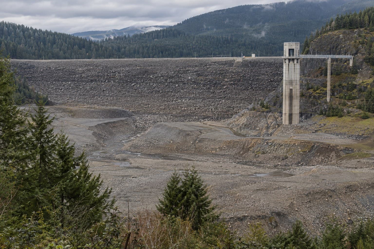
Mud Mountain Dam is 432 feet tall, was briefly the tallest of its kind on Earth, holds no lake, and spends most of the year doing nothing. Then it rains.
Drive east out of Enumclaw on Highway 410 and, about eight miles along, you will pass the largest thing anyone ever built on the plateau. You will not see it. There is a brown sign, a side road, and then the highway carries on toward the mountain as if nothing happened.
Mud Mountain Dam sits in a canyon on the White River, on the King and Pierce county line, and it is 432 feet high: 2.3 million cubic yards of sand, gravel and quarry rock, 1,600 feet thick at the base. When the Army Corps of Engineers finished it in 1948, no dam of rock and earth anywhere on the planet stood taller. And yet nobody looks, because from the highway there is nothing to look at.
The river nobody wanted
The White River comes off the Emmons and Winthrop glaciers on Mount Rainier already carrying a load of pulverized mountain, which the Corps calls glacial flour. It is why the river is the color of dishwater in August, and why it never stays in one channel: a river hauling that much rock builds its own bed up until it spills over the side.
From the 1870s on, farmers in the lower valley flooded almost every winter. Their solution was dynamite. HistoryLink's Alan Stein records that they would blast open a new channel, which sent the water onto somebody else's farm, who would then buy his own dynamite. In 1906 a flood shoved the whole river south into Pierce County, which sued, and it took until 1913 for the two counties to agree on who would pay to control it.
Then December 1933 arrived: roughly 57,000 cubic feet per second past the gauge at Puyallup, about $950,000 of damage, and a line in the Corps' own manual calling it "by far the most destructive flood in the history of the valley." Two counties gave up and called the War Department. Congress answered with the Flood Control Act of June 22, 1936.
They wanted to build it out of concrete
The first plan was an arch dam, because a geological report had called the canyon rock a hard, unfissured andesite. The Corps looked closer, found what its manual delicately calls "geological peculiarities," and picked the least glamorous of five designs: a rolled earth core wrapped in dumped quarry rock. A very large, very carefully engineered pile.
A camp with bunkhouses for 400 men went up in 1937, with no store, because Enumclaw was right there. Bids opened on August 21, 1939; the Guy F. Atkinson Company won at $5,344,605. On September 1, 1940, they diverted the river into a 23 foot tunnel and went to work on the dry riverbed.
On July 27, 1942, the government stopped the job for the war, and the dam sat almost complete for five years. Work resumed in 1947, the last valves went in during 1948, and sometime that May or June the river celebrated by tearing the radial gate off the small tunnel and carrying it downstream. The Corps never fully established why.
Tallest for about two years
The world record line still sits on the Corps' visitor page, and it is true, with an asterisk. The record was for rock and earth fill; Hoover was already 726 feet of concrete. And it did not last. Anderson Ranch Dam in Idaho, a 456 foot embankment, was finished in 1950 by the Bureau of Reclamation's count. So for roughly two years the tallest pile of rock on the planet was eight miles from the Enumclaw fairgrounds.
There is no lake
Maps show a Mud Mountain Lake. There is no Mud Mountain Lake. The reservoir is "normally empty," in the Corps' phrase, and the White River simply runs through the base of the dam in a nine foot horseshoe tunnel as if the dam were not there. The dam is a wall with a hole in it.
When a real storm comes, the operators choke the tunnels and the canyon fills. Full pool is 1,215 feet above sea level, 106,000 acre feet of water in a lake five and a half miles long. Once the Puyallup River downstream drops back inside its levees, they let it all out again, fast, so the sediment on the reservoir floor washes through instead of piling up. The lake exists for a week or two. Nobody has ever water skied on it, and water has never gone over the top, though the Corps raised the spillway walls nine feet in 1992 anyway.
The nights it earned its keep
The dam's worst night was in February 1996, when warm rain fell for five days on frozen ground and fresh snow. Inflow peaked at 29,560 cubic feet per second. The operators shut the outflow off completely for nearly eight hours, filled 84 percent of the flood storage, and let the pool climb to 1,196.1 feet, nineteen feet below the lip of the spillway. The Puyallup still touched the top of the levee in Puyallup at 46,700 cubic feet per second; without the dam, the Corps calculates, it would have hit about 76,000. That one storm prevented an estimated $146.1 million in damage.
The next test came last December. In the storms of December 2025 the pool rose to 1,185 feet, about seventy percent of capacity, and by the Corps' reckoning the Puyallup ran close to two feet below where it would otherwise have been through the city of Puyallup. Their preliminary figure is $215 million in damage avoided for about 400,000 people in the lower valley. The dam does not make floods impossible. It makes them survivable, and there is a catch, made of the same glacial flour that started all this: the levees below Auburn were built for 25,000 cubic feet per second, but the riverbed through Pacific and Sumner has silted up so badly that the Corps now holds routine releases far below that: 12,000 under its 2004 manual, and about 7,060 since 2009, according to a 2019 King County and USGS sediment study.
Salmon by truck
The dam that stops the water also stops the fish. The original plan was a tramway that would carry salmon over the top in buckets. That was abandoned, and the Corps settled on something stranger: a trap at the old diversion dam in Buckley, five miles downstream, from which salmon have been driven around the dam in tanker trucks since 1949.
That meant a timber and steel crib dam from about 1911, eleven feet high and 352 feet long, that fish threw themselves at. A Puyallup Tribe biologist told KUOW in 2018, "It's just a lot of spikes, nuts, bolts, metal, wood. When they're jumping aimlessly at it, they just get injured." The National Marine Fisheries Service ordered a replacement in 2007. The Corps pleaded poverty for a decade.
The money came in March 2018: a $112 million contract to Kiewit. The new facility opened on February 17, 2021, on the Enumclaw side of the river this time, and it is the largest trap and haul operation in the country. Archimedes screw lifts raise the fish into flumes, and trucks carry them up Mud Mountain Dam Road, onto 410 at the east edge of town, and about twelve miles upriver to be let go. The old trap was designed for 20,000 fish a year. The new one can move 60,000 a day.
In 1986 six White River spring Chinook came home; by 2017, after a Muckleshoot hatchery and a Puyallup Tribe radio tagging study, the count was 16,271. King County calls them the last spring run Chinook left in south Puget Sound. Every one of them has ridden through Enumclaw in a truck.
Go look at it
The recreation area is at 30525 SE Mud Mountain Road, off 410. The Vista Trail drops 260 feet in a third of a mile to a deck where the dam finally appears: the sloped rock face, the intake tower, the empty canyon and, in winter, the booms strung across the water to catch whole trees, which the Corps tows to a basin upstream, cuts up with chainsaws and burns.
Sumner, Puyallup, Fife and the Tacoma tideflats are dry because of a pile of gravel in a canyon they have never seen. Enumclaw and Buckley live beside it and rarely mention it. It works by being empty, it is famous for being tall, and it is invisible from every road you normally take. On the plateau, that is about as close to a monument as we get.
Story label: Original Story or Guide
Originally published: