

Feature
For 92 years, most of the White River took a detour through a lake
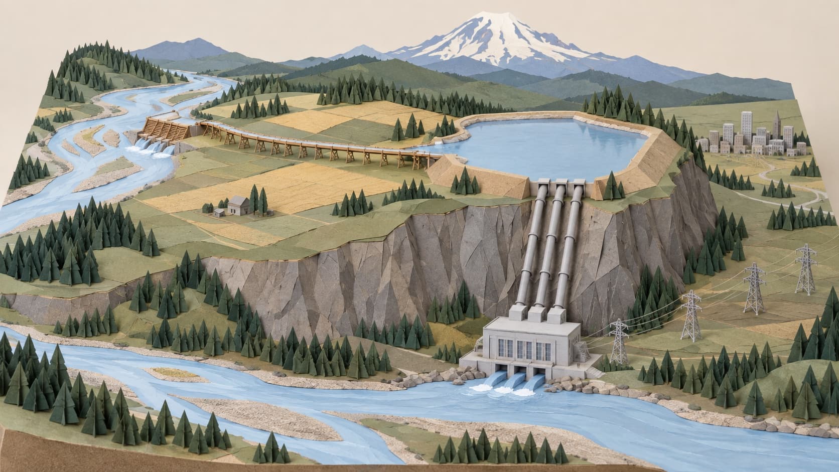
A Boston firm dammed the White River at Buckley in 1910 and ran most of it into Lake Tapps to make power. The plant closed in 2004. Who owns the detour now.
Lake Tapps is not a lake in the ordinary sense. It is what a power company made out of four small ones, and the reason it exists is a low barrier across the White River just upstream of the 410 bridge at Buckley, easy to miss because it makes no reservoir. It makes a decision. For 92 years the decision was that most of the White River would not continue down its bed to Auburn, but would leave the bed on the Buckley bank, into a wooden flume, and go to Lake Tapps instead.
A Boston company and a plateau full of lakes
The idea is older than the dam. An engineer named A. McLean Hawks proposed in the 1890s to divert the White River at Buckley and carry it to a lake on the Enumclaw plateau, and after a decade of corporate fighting that the Historic American Engineering Record narrates in some detail, the winner was the Pacific Coast Power Company, a subsidiary of the Boston engineering firm Stone and Webster. In November 1908 the company began condemnation proceedings against members of the Muckleshoot Tribe who held allotments along the river. The decrees granting the right to divert came in April 1910.
Construction started early that year with a hundred men. By September there were more than 1,500, living in seventeen camps strung between Buckley and Dieringer. The whole system was built in twenty months, and the federal record gives the finish line precisely: power was delivered commercially for the first time on November 1, 1911.
A year later the company merged with the other Stone and Webster plants and the street railways into Puget Sound Traction, Light and Power, which became Puget Sound Power and Light, which became Puget Sound Energy. The White River plant, the engineering record says, was the controlling works of the largest hydroelectric system in western Washington.
How it worked
At Buckley, a timber crib dam 352 feet long, filled with rock, only four feet high in its permanent part, carried seven-foot flashboards on top that were designed to fold flat in a flood so the river could pass over. Behind it, water turned into a system of flumes, canals and settling basins about seven miles long and crossed the plateau to a natural basin that held four lakes: Tapps, Kirtley, Church and Crawford. Nineteen earthen embankments raised the water 35 feet and made the four into one reservoir.
At the west end of the new lake a concrete-lined tunnel 3,000 feet long and twelve feet across led to a forebay and then to steel penstocks, which dropped 440 feet down the edge of the plateau to a three-story reinforced concrete powerhouse at Dieringer. Two Francis turbines rated at 18,000 horsepower each turned 10,000 kilowatt General Electric generators. A third unit came in 1918, a fourth in 1924. The tailrace put the water back into the river, or rather into the Stuck River. That is what the lower White became after a 1906 log jam sent the whole flow south instead of north to the Green.
The clever part was the lake. Snoqualmie Falls ran on whatever the river gave it; Lake Tapps stored enough water, the engineering record says, to run the plant at full capacity for a considerable period. From 1912 the system used it for peaking, the expensive hours of the day.
What it took from the river
Up to 2,000 cubic feet per second, according to King County's 2002 study of the corridor. The USGS gauge at Buckley puts the river's average at 1,435. In some periods, the Seattle Times reported in 2003, as much as nine-tenths of the White River went into the lake, and the roughly twenty river miles from the dam to the point where the water came back, which the agencies call the bypass reach, carried only the minimum flow deemed necessary for fish. Through the Muckleshoot reservation, between river miles 16 and 9 by Ecology's count, the White was, in the words of the tribal council's chair, Charlotte Williams, often reduced to a trickle.
Once, the two dams together killed two children. On July 15, 1976, the Army Corps of Engineers released 2,638 cubic feet per second from Mud Mountain Dam to flush silt, and ten minutes later operators at the diversion dam below pulled seven flashboards to keep the silt out of the flume, adding another 1,750. The surge drowned two girls, nine and ten years old, near Pacific. The state's investigation blamed a lack of coordination between the two dams.
The trap
Three years after the dam was built, the company improved a fish ladder over it. That ladder, the engineering record says, stayed substantially as it was until 1940, when the Corps built a fish trap at the diversion dam to catch spawning salmon and truck them above the new Mud Mountain Dam, seven miles southeast of Enumclaw, which was finished in 1948 and blocks everything. This site's piece on Mud Mountain covers the trucks. The point here is placement: the Corps put its trap at the barrier that was already there.
The old trap was built for 20,000 fish a year. By 2013 the pink run had grown to nearly a million, spring Chinook had come back from a handful in 1986 to thousands, and Billy Frank Jr. was writing that the exposed boards and rebar of the 1910 dam were wounding threatened fish. In 2018 the Corps awarded Kiewit a $112 million contract for a new facility, and in February 2021 it dedicated one that can move 60,000 fish a day, on the Enumclaw side of the 410 bridge, which the Courier-Herald and the Corps call the largest of its kind in the nation and which its project manager, Leah Hauenstein, said might be the largest in the world. Cascade bought the old diversion dam with the rest of the system; the trap is the Corps'.
Why the turbines stopped
The federal government told PSE in 1962 that the project needed a license. PSE fought the question of jurisdiction until 1981. On December 19, 1997 the Federal Energy Regulatory Commission issued a fifty-year license with conditions, and PSE said the conditions, chiefly leaving more water in the river, made the plant uneconomic. The license was stayed in 1999 and again in 2001 while a Lake Tapps task force looked for a way out.
The company's position in 2003 was that the fish were recovering with the flows they had. A federal fisheries report that November said the plant drew too much water and threatened Chinook. On November 21, 2003 PSE decided that continued operation was economically untenable, and at one in the morning on January 15, 2004, the Courier-Herald reported, the four generators at Dieringer came to a quiet stop. The manager of the White River facility, Charles Morton, said: "It's a sad day, to close it down. But times have changed and we have to go with the flow." Most of the flow went back into its bed after that, the state's later report says, with a much smaller share still diverted to hold the lake's level.
Who owns a detour
Cascade Water Alliance, a group of King County cities and water districts, agreed in April 2005 to buy the whole system from PSE, the dam, the flume, the lake, the dikes and the powerhouse, for $10 million plus up to $27 million when the state granted municipal water rights; Cascade's own summary now gives the cost as $40 million. It closed the purchase on December 18, 2009, after a 2008 management agreement with the Puyallup and Muckleshoot tribes that the Muckleshoot chair, Charlotte Williams, called a milestone in the restoration of the river. The Department of Ecology issued the water rights on December 10, 2010: a diversion right, a storage right, a municipal withdrawal averaging 48.5 million gallons a day, and a change to a hydroelectric claim dated 1895.
Cascade does not expect to need the water before 2040. In the meantime the dam still turns a much smaller share of the river into the flume to keep Lake Tapps full for the people who live on it, and every November 1 Cascade begins drawing the lake down for winter.
The Enumclaw side
The powerhouse sits at the foot of the Enumclaw plateau. The water it dropped was collected on the plateau. Three quarters of the river corridor land PSE set aside under its wildlife plan, King County found in 2002, lies inside the Enumclaw Agricultural Production District, the farm belt between the reservation and town. And the new fish facility is on this side of the bridge.
So the river that runs past Enumclaw spent the twentieth century making electricity for the largest utility in the state, and has been reserved, for the twenty-first, as drinking water for cities on the far side of the county. Enumclaw drinks from its own springs and wells. It got the flume, the trucks and the view.
Story label: Original Story or Guide
Originally published: