

Feature
Mount Rainier lenticular clouds, and what the hat means
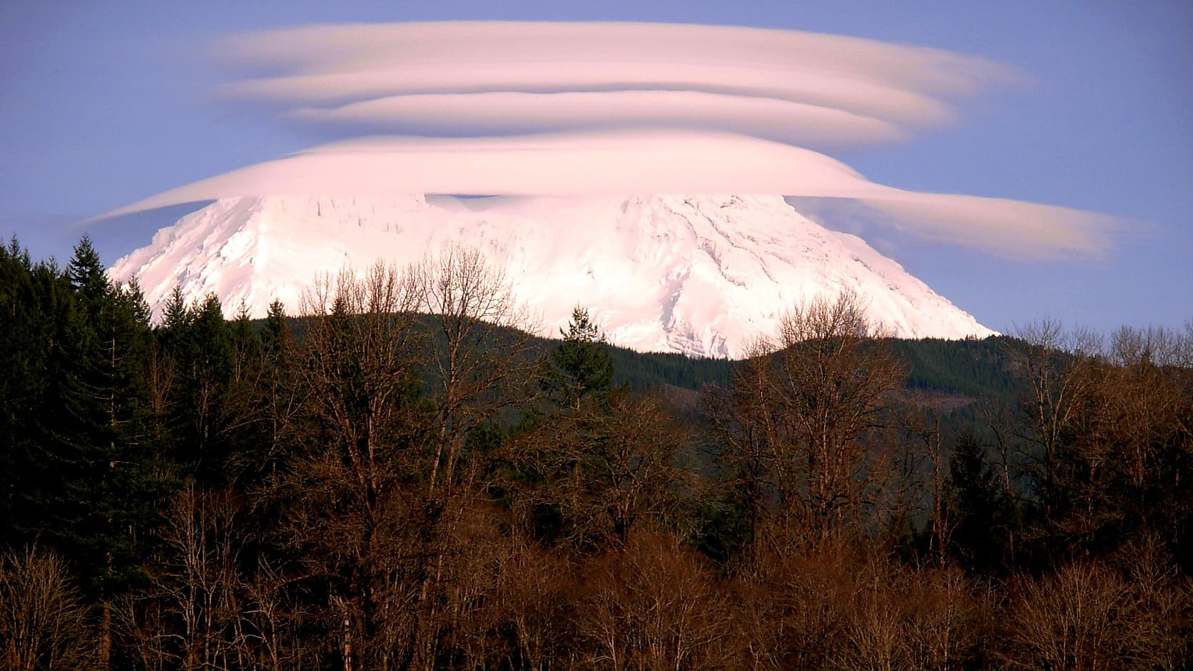
Mount Rainier lenticular clouds mark a standing wave of moist air. What the hat says about rain, why climbers and pilots heed it, and the 1947 UFO theory.
A lenticular cloud over Mount Rainier is a smooth, lens-shaped cloud that forms where moist air flowing over the mountain rises in a standing wave, a ripple in the wind that holds its place, and condenses at the crest; from Enumclaw it can make the summit look as if it is wearing a hat or has a flying saucer parked on it. The cloud itself makes little or no rain, by the World Meteorological Organization's International Cloud Atlas. It does mark moist air moving steadily over the mountain, which KOMO's weather explainer says tends to arrive in the hours before a weather system, so locals read it as rain on the way, usually within 24 hours. In 1934 the park's naturalists gave the rule as rain in a few days and called it no sure thing.
The cloud that looks parked is a wind gauge. Air blows straight through it, condensing on the upwind edge and evaporating off the downwind one, as the Federal Aviation Administration's Aviation Weather Handbook describes it. When the agency issued a 1997 advisory circular teaching pilots to read hazardous mountain winds from clouds and other visual clues, the last photograph in its picture atlas was this mountain in its hat: "a striking picture of a cap cloud that has developed over Mt. Rainier, Washington."
What is a lenticular cloud?
It is a cloud shaped like a lens or an almond, usually with sharp edges, and the WMO atlas, the international standard for classifying clouds, says it appears most often among clouds that mountains make. The National Weather Service glossary adds that lenticulars are very smooth and come singly or stacked, near a ridge or downwind of it. The atlas says they hold still in strong wind, moving very slowly if at all, usually for some hours and seldom more than a day, and reads them as a sign of strong wind in stable air at middle altitudes. They also stack: one lens or a pile of several often sits above a mountain, and Cliff Mass, a University of Washington professor of atmospheric sciences at the time, wrote on his weather blog in March 2012 that the extra plates appear when the moisture comes in layers.
Why does Mount Rainier wear a hat?
Because it stands alone in the path of wet Pacific air. The National Park Service's roadside Weather-Maker panel in the park describes the mountain towering like an island in the clouds, making its own weather and drawing in wet storm fronts from the Pacific. When stable air, the kind that sinks back once lifted instead of boiling up into towers, crosses the mountain on a strong, steady wind, the atlas says it rises and falls downstream in mountain waves, and wherever a crest is moist enough a cloud forms and stays. Over an isolated peak, it adds, the result is a collar around the mountain or a cap over the top. On the March 2012 day Mass blogged about, the air arriving at the coast on a southwest wind was close to saturation, nearly full of water vapor, above about 18,000 feet, and lenticulars stood downstream of both the Olympics and Rainier. By his account, mountain waves over the Cascades also help turn Enumclaw's east wind from strong to violent.
Is a cap cloud the same as a lenticular cloud?
Not quite, though the hat over Rainier can be either, or both at once. The National Weather Service defines a cap cloud as a stationary cloud directly over an isolated peak with its base below the summit, so it hides the top; a lenticular is the free-floating lens above the peak or downwind of it. In the atlas the cap forms as air is shoved up the windward slope, and lenticulars ride the wave crests beyond. A third relative, the banner cloud, streams off the summit like a flag in strong wind. In the photograph above, the lowest plate lies just over the summit with more stacked on top.
Does a hat on Rainier mean rain?
Often, by local reckoning, though no published tally of its hits and misses turned up. KOMO's explainer, written by Scott Sistek in 2006 and updated in 2017, says locals take the clouds as a sign of rain on the way, usually within 24 hours, because the moist, smoothly flowing air they need tends to show up in the hours before a weather system. The cloud itself drops little or no rain: the WMO atlas says lens clouds made by mountain waves "do not produce precipitation," and that a cap over an isolated mountain gives little or none. A cap can sit for days with no rain falling around the mountain, as a park nature guide noted in 1925.
How long have people read Rainier's cap as a forecast?
At least a century, and the caveats are just as old. On July 21, 1925, Mount Rainier Nature News Notes, the newsletter of the park's nature guides, ran a piece by one of them, Charles Landes, that began: "All the old timers about the mountain use its clouded summit as a barometer." When a cap settled on the summit after clear weather, he wrote, the old-timers predicted a storm, and he judged them right a large share of the time. He also logged a miss of sorts: a distinct cap had sat on Rainier for several days ahead of a rain that fell widely along the coast, and none fell in his region. In 1934 the park's Nature Notes printed the line its naturalists gave visitors worried about the weather: "Well, there is a cap on the mountain, so we may have rain in a few days." It added that a cap was no absolute indication of rain, only a general sign of bad weather coming. Reading the mountain is still a plateau habit, as this site's essay on living with a mountain that keeps its own hours describes.
Are lenticular clouds dangerous?
The cloud is not the hazard; the wind it marks is, mostly for the people up in it. The park's Weather-Maker panel warns that a cloud on the summit may look harmless from below while it is "probably lashing climbers with an intense, localized blizzard," and Landes wrote in 1925 that such clouds sometimes turned climbers back on days that were calm and sunny at the mountain's base. For pilots the danger is turbulence. The FAA's handbook says that when mountain waves are running, a rotor zone, a big rolling eddy near or below ridge level, often forms downwind of the mountain under a wave crest and its lenticular, can hold severe to extreme turbulence and wind shear, sharp changes in wind speed or direction, and should be avoided. The 1997 circular called cap and banner clouds signs of strong, turbulent wind near the ridgetops. The FAA cancelled the circular in December 2022, folding its weather guidance into a new handbook, and the handbook's 2026 edition repeats the rotor warning nearly word for word.
Did a lenticular cloud start the 1947 UFO craze?
Cliff Mass has said so, though the sighting as usually told is hard to square with it. When his book The Weather of the Pacific Northwest came out in November 2008, Mass told the University of Washington's news office that "the whole UFO craze started here in the late 1940s when someone saw what looked like a UFO over Mount Rainier." What that person really saw, the office reported him as saying, was a lenticular cloud. Mass did not name the pilot. HistoryLink, the online encyclopedia of Washington history, dates the craze to Kenneth Arnold's sighting of June 24, 1947, and says Arnold, flying his own plane near the mountain, watched nine gleaming objects race south along the Cascade crest for about two minutes. Wave clouds do not race; the atlas says they hold their places for hours. This site's piece on how the words flying saucer began as a figure of speech tells the rest of Arnold's afternoon, and the comparison still comes easily: a photographer on Prairie Ridge, about 9 miles southwest of Enumclaw by the picture's map coordinates, caught a lone lens beside the mountain in January 2008 and titled the shot UFO-like cloud at Rainier.
Where and when can you see one from Enumclaw?
From almost anywhere in town with a clear line to the summit, which lies about 27 miles south-southeast of City Hall in a straight line, by the coordinates the USGS and OpenStreetMap give for the two. The plateau faces the mountain's north side, the Willis Wall and Liberty Ridge. No agency count of hat days, or season for them, turned up; the park leads its weather page with a photograph of lenticulars clinging to the peak, and Steve Redman, photographing for the park, caught them in January 2011 and again that July. Watch for one in the hours before a weather system, winter or summer. When the summit is hidden from where you stand, as of October 2026 the Mount Rainier webcams page carries a free view of the mountain from Paradise; its two Sunrise cameras come down for the winter, and the page says to check back in summer 2027. A privately run stream from Enumclaw that this site wrote about in August 2026 shows the mountain from town when it is running.
Before you go out to look
Check the sky first and the forecast second. The webcams show whether the summit is clear, and for whether rain is really coming, the National Weather Service forecast posted on the park's weather page beats any hat. Climbers and pilots should read the cloud as a wind report: the park tells climbers to watch one-day and long-range forecasts, avalanche warnings and special weather alerts, and the FAA tells pilots to stay out of rotor zones. Everyone else gets the easy part. The cloud will usually hold still for the picture.
Story label: Original Story or Guide
Originally published: