

Feature
Biggest earthquakes in Washington state history, ranked
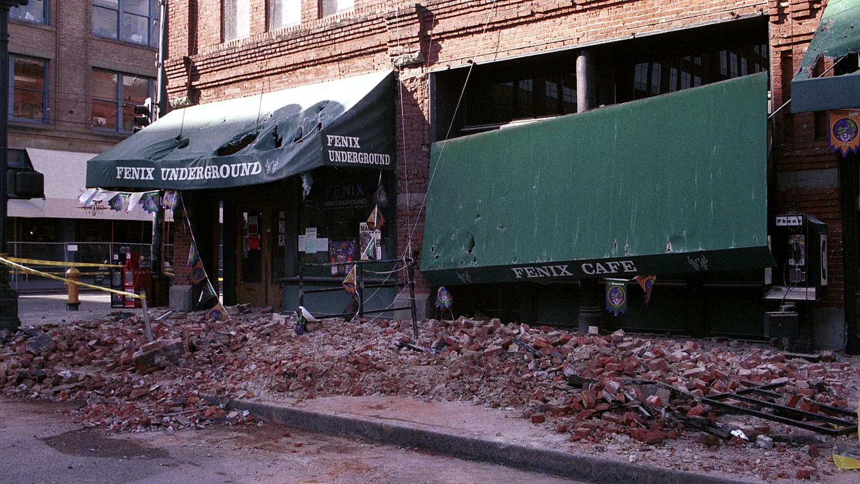
The biggest earthquake in Washington state history was Cascadia's in 1700, near M9. Since then, 1872 and 2001 lead at 6.8; 1949 and 1965 tie at 6.7, per USGS.
The biggest earthquake known to have shaken Washington is the Cascadia Subduction Zone earthquake of January 26, 1700, which the Pacific Northwest Seismic Network puts between magnitude 8.7 and 9.2. In the written record, the two largest centered inside the state are the Lake Chelan earthquake of December 14, 1872 and the Nisqually earthquake of February 28, 2001, each listed at magnitude 6.8 in the U.S. Geological Survey's earthquake catalog as of October 2026. The Olympia quake of 1949 and the Seattle-Tacoma quake of 1965 come next at 6.7 apiece, and like Nisqually they began 30 to 40 miles underground, with epicenters, the points on the surface above, 21 to 35 miles from Enumclaw City Hall.
Neither 6.7 is the number the federal reports on those quakes printed. The Coast and Geodetic Survey's 1951 report put the 1949 quake at magnitude 7.1, the figure HistoryLink and even the seismic network's Nisqually page give, and the survey's report on 1965 said 6.5. The USGS catalog lists both at 6.7 in moment magnitude, the type it calls more accurate than Richter's for all but small local quakes, using figures from ISC-GEM, an international project to improve the instrument records of large earthquakes since 1904. The gap matters. Each whole step on the scale releases about 32 times more energy, the USGS says, so a 7.1 carries roughly four times the energy of a 6.7.
1. Cascadia earthquake, 1700: magnitude 8.7 to 9.2
It happened offshore, on the fault where the Juan de Fuca plate slides beneath North America, and by the seismic network's account of the 1700 earthquake the rupture ran along much of its 1,000 kilometers (about 620 miles), potentially from Vancouver Island to Cape Mendocino, California. Nobody in the Northwest wrote it down. The date comes from Japan, where a tsunami arrived in late January 1700 with no local quake to explain it; allowing about nine hours for the crossing, PNSN puts the earthquake at around 9 p.m. on January 26.
Tree rings agree. Coastal forests are thought to have died of salt water when the shore dropped 1 to 2 meters (3.3 to 6.6 feet), and rings from those ghost forests, like the one PNSN pictures at Copalis Beach, date the deaths to the winter of 1699 to 1700. Coast Salish and Nuu-chah-nulth oral histories, as the network sums them up, tell of shaking so violent that people could not stand. By the USGS's 32-times rule, a quake of 8.7 to 9.2 releases roughly 700 to 4,000 times the energy of Nisqually.
2. Lake Chelan or North Cascades earthquake, 1872: magnitude 6.8
One of the two largest quakes in the state's written record struck on the night of December 14, 1872, with no seismometers to measure it. The catalog's 6.8 is a felt-area magnitude, estimated from how large an area felt the shaking; a 2002 study by USGS and PNSN seismologists put its moment magnitude at 6.5 to 7.0, and PNSN gives 6.8 to 7.2.
That study placed it near the south end of Lake Chelan, the name the catalog uses. In 2014 Brian Sherrod, then a USGS researcher, found a fault scarp, the scar a quake leaves where it cracks the surface, in Spencer Canyon near Entiat, and PNSN, which calls it the North Cascades earthquake, says that fault was probably the source. By the catalog's account a landslide at Ribbon Cliff blocked the Columbia River for several hours, and water spouted as high as about 30 feet from a hole at Chelan Falls. So few people lived nearby that damage was light, though PNSN says the shaking knocked people down as far away as Snoqualmie Pass.
3. Nisqually earthquake, 2001: magnitude 6.8
At 10:54 a.m. on February 28, 2001, a fault broke 52 kilometers (32 miles) beneath Anderson Island, near the Nisqually River delta, inside the sinking Juan de Fuca plate, by PNSN's account. The catalog's headline 6.8 is a duration magnitude, based on how long the shaking lasts on the record, and its moment magnitude solutions agree. The catalog's Nisqually page calls it, as of July 2026, "one of the two largest-magnitude earthquakes located within the State of Washington."
About 400 people were hurt. PNSN and the state Emergency Management Division attribute one death to it, a heart attack, in Burien by HistoryLink's account, though a USGS statement the division quoted in 2019 counted none. The division puts damage at $500 million to $4 billion, PNSN at about $2 billion. Olympia, Sea-Tac Airport and Pioneer Square, where the brick in the photo above fell, were hit hardest; more than a thousand unreinforced masonry buildings, the old brick kind, were tagged unsafe to reoccupy, and the Capitol closed for more than three years after its dome shifted, PNSN says. Nothing larger than magnitude 5.0 has been centered in Washington since, by the catalog through mid-October 2026.
4. Olympia earthquake, 1949: magnitude 6.7
At 11:55 a.m. on April 13, 1949, a deep quake struck between Olympia and Tacoma: moment magnitude 6.7 at 50 kilometers, about 4 kilometers west-northwest of Roy, in the catalog, and 7.1 in the 1951 federal report, which counted eight deaths, direct or indirect, and damage upwards of $25 million.
Eight Capitol buildings in Olympia were damaged, a $2 million loss, and at the Tacoma Narrows the shaking threw a 23-ton cable saddle off the top of a bridge tower. Maximilian Dixon, then the geologic hazards supervisor at the state Emergency Management Division, said in 2019 that 1949 is remembered less than 1965 or 2001, "and yet it's probably the most damaging of the three."
5. Seattle-Tacoma (Puget Sound) earthquake, 1965: magnitude 6.7
On the morning of April 29, 1965, the deepest of the three began 64 kilometers (40 miles) down, near Dash Point between Tacoma and Seattle: moment magnitude 6.7 in the catalog, 6.5 in the Coast and Geodetic Survey's report for the year. That report counts three people killed by falling debris, one on South King Street in Seattle and two at the Fisher Flouring Mills on Harbor Island, and four elderly women whose deaths from heart failure were attributed to the quake; the State Civil Defense Department put damage at about $12.5 million. The damage largely repeated 1949's, the USGS summary says, down to Alki Beach in West Seattle, where almost every chimney came down.
Why do Washington's worst earthquakes start so deep?
Because most of them break inside the Juan de Fuca plate as it sinks beneath the Puget Lowland. PNSN names three kinds that can do real damage: the offshore Cascadia megathrust; deep quakes inside the sinking slab, typically 30 to 70 kilometers (20 to 45 miles) down; and shallow crustal quakes, no deeper than about 35 kilometers. It traces most of Washington's damaging historic earthquakes, 1949, 1965 and 2001 among them, to the deep source, which has produced a damaging quake about every 30 years. Depth spreads the energy, so shaking is milder at the epicenter but reaches farther.
The catalog's next tier tells the same story: a moment magnitude 6.1 late on November 12, 1939, 55 kilometers under Puget Sound (PNSN says 6.2); a 6.0 near the San Juan Islands on January 11, 1909, which PNSN also counts as deep; and a 5.8 near Satsop in 1999, 40 kilometers down. Another 5.8, under Puget Sound in 1946, is listed at only 25 kilometers, shallower than the usual 30 to 70 for deep quakes. The clearly shallow exceptions are 1872 and the State Line earthquake near Walla Walla and Milton, Oregon, on the night of July 15, 1936, moment magnitude 6.0 at 10 kilometers in the catalog (6.1 in PNSN's archive). About 70 percent of the stones in the area's cemeteries were later found turned clockwise, the federal report says.
What did the big earthquakes do in Enumclaw?
Enough to break windows, by the federal government's town-by-town reports, which PNSN has transcribed. In 1949 the Coast and Geodetic Survey rated Enumclaw at intensity VII on the Modified Mercalli scale, the I-to-XII measure of what shaking does in one place, and the town's entry reads in full: "Few chimneys damaged, plaster cracked. Damage slight. Trees and bushes shaken strongly." Several neighbors rated VIII, though Black Diamond matched Enumclaw at VII. In Buckley, "Part of high school building fell," and most chimneys toppled at the roofline; in Wilkeson, the coal town known for its beehive coke ovens, several houses ended up a few inches off their foundations; in Auburn the junior high was condemned.
In 1965 Enumclaw rated VII again, with considerable damage this time: broken windows, fallen pictures and plaster, shifted furniture and a minute of rapid east-west motion. The survey also set up a temporary seismograph in town to catch aftershocks. In 2001, 28 people in Enumclaw's 98022 ZIP code answered the USGS's Did You Feel It? survey, and their reports averaged intensity 6.2, in the band the USGS describes as felt by all, many frightened, damage slight; Buckley's 15 reports averaged 6.4. The Capitol in Olympia, damaged in 1949 and 2001, is clad in the Wilkeson sandstone quarried up the road.
Could a bigger earthquake hit Enumclaw?
Yes, though no one can say when. "Neither the USGS nor any other scientists have ever predicted a major earthquake," the agency's FAQ says; science offers odds instead. PNSN counts at least 19 great Cascadia earthquakes, magnitude 8 or more, in about 10,000 years, about one every 500 years, and relays a USGS estimate of a 10 to 15 percent chance of a full-margin magnitude 9, rupturing the whole coast, in the next 50 years. For a deep quake of 6.5 or more in the region, PNSN gives the USGS estimate as 85 percent in 50 years; its Nisqually page says 84 percent for one larger than 6.0.
Crustal faults sit closer. PNSN says the biggest in the region could produce a magnitude 7.5, and that the Seattle fault, which runs through the city, left a record of a large earthquake in the year 900. The nearest fault in the USGS Quaternary Fault and Fold Database, its list of faults believed to have produced quakes above magnitude 6 in the past 1.6 million years, is the Tacoma fault, whose simplified mapped trace comes within about 8.5 miles of Enumclaw City Hall, to the west-northwest in Pierce County. Mount Rainier's mudflow hazard is a separate question, covered in the guide to Enumclaw and the lahar zone.
What to do when the shaking starts
Drop, cover and hold on, says the state Emergency Management Division: get down on your hands and knees, take cover under a sturdy desk or table with a hand over your head and neck, and hold on until the shaking stops. Ready.gov, the federal preparedness site, adds: stay inside, avoid doorways, pull over and set the parking brake if driving, and expect aftershocks. USGS ShakeAlert warnings have reached Washington phones since May 4, 2021. As of October 2026, the division says Wireless Emergency Alerts go out for quakes of 5.0 and up, to places where the shaking would rattle dishes and windows, and that most Northwest quakes allow 10 seconds of warning or less, sometimes none.
Afterward, a gas smell in Enumclaw is the city's to handle, since the city runs its own gas utility. As of October 2026, its natural gas page lists 360-825-5541 from 9 a.m. to 4 p.m. and 360-825-3505 from 4 p.m. to 7:30 a.m., and says to call 911 in an emergency. The power outage guide has PSE's numbers, and the 911 explainer shows how a call is routed. Report what you felt to the USGS's Did You Feel It? survey. The Great Washington ShakeOut drill falls on the third Thursday of October each year: October 15 in 2026, when Fox 13 reported it set for 10:15 a.m., and October 21 in 2027. The division's earthquake page has the current details.
Story label: Original Story or Guide
Originally published: