

Feature
Dry Falls in Washington, and the Ice Age floods behind it
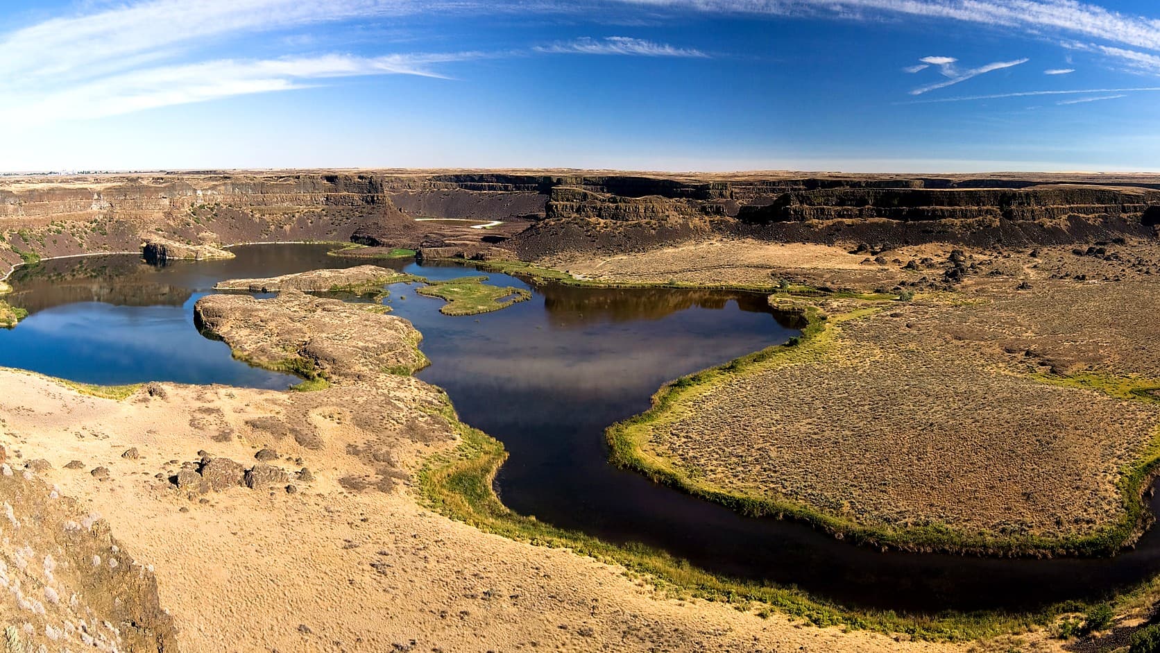
Dry Falls in Washington is a cliff 400 feet high and 3.5 miles wide. As of October 2026 the visitor center is closed; hours, pass and the drive from Enumclaw.
Dry Falls is a cliff 400 feet high and 3.5 miles wide in Sun Lakes-Dry Falls State Park near Coulee City, in Grant County, where Ice Age floodwater once poured over the edge in a waterfall the National Park Service puts at four times the size of Niagara Falls. It is about 200 miles and four hours from Enumclaw by road. As of October 2026, the Dry Falls Visitor Center on State Route 17 is closed for renovation through the end of 2026, while the park around it stays open from 8 a.m. to dusk and parking takes a Discover Pass.
The man who explained the place was told for years that he was wrong. J Harlen Bretz, a University of Chicago geology professor, spent eight summers in this country and argued in 1923 that a flood of glacial meltwater had carved it. Established geologists, Washington State Parks' park history says, called the thesis an "outrageous hypothesis." In 1965 a group of geologists touring the region sent the 83-year-old Bretz a telegram that read "We are all now catastrophists." The park's visitor center was dedicated to him in 1994.
How big is Dry Falls, and was it bigger than Niagara?
By the National Park Service's description, the cliff is 400 feet high and 3.5 miles wide, and the waterfall it held was four times the size of Niagara Falls. The Bureau of Reclamation, in a geology summary for Grand Coulee Dam, gives the same height and width and calls that five times the width of Niagara. A State Parks article on the floods says four times wider. The agencies do not agree on the multiple, so "four or five times" is the safe way to say it.
The old word for a large waterfall is a cataract, and Dry Falls is a dry one, because no river pours over it. At the foot of the cliff lie the plunge pools, the basins where falling water scoured the rock; State Parks says they are groundwater-fed lakes. Dry Falls was not even the largest in the neighborhood. State Parks says Steamboat Rock is thought to be the remnant of a twin waterfall at the head of the Grand Coulee, twice the height of Dry Falls, and Reclamation puts the larger of the Grand Coulee's two cascades at 800 feet.
What caused the Ice Age floods that made Dry Falls?
The National Park Service traces them to ice dams in western Montana, in its article on the floods. Near the end of the last Ice Age, a lobe of the Cordilleran ice sheet blocked the Clark Fork River, and the valleys behind the ice filled to make Lake Missoula, covering about 3,000 square miles. By the Park Service's account, the ice gave way as many as 100 times between 15,000 and 13,000 years ago, an estimate from geologists, and each flood lasted about a week while the water raced across eastern Washington toward the Pacific. These are the Missoula floods, or Ice Age floods.
The count and the dates vary by agency. Reclamation says at least 70 floods. The Washington Department of Natural Resources gives 18,000 to 12,000 years ago for the whole series. What the sources share is the result: a landscape State Parks describes as a "vast landscape of dry canyons," the Channeled Scabland, which is basalt stripped of its soil. Reclamation says the second of the Grand Coulee's two cascades cut back to form Dry Falls.
Is Dry Falls open in winter, and what is closed in 2026?
The park is open in winter and the visitor center is not, but some winter closures apply. The renovation project page says the park "is open year-round for camping and recreation (Note: Deep Lake and Dry Falls close each winter)," without saying which gates or areas that covers. State Parks lists the park's winter hours as 8 a.m. to dusk and its summer hours as 6:30 a.m. to dusk; its brochure sets the winter schedule at October 1 to March 31. The center's page says the building "will be closed for renovations through the end of 2026," including its bathrooms and parking lot. The project page gives a $2.3 million budget, an estimated April 1 to December 31, 2026 schedule and an expected reopening "in winter of 2026," and says the outdoor overlook would close when construction began.
The same page offers the way around it: the falls and scablands remain visible from Sun Lakes State Park, below the center. It also says the park has year-round restrooms three miles from the center. Other changes come with the season. Campsites 1 to 31 close November 1 by the park page, and the winter schedule says the Dry Falls Lake gate will close December 1, and the Deep Lake gate closure is weather dependent by the same page. Dates like these move, so the Dry Falls Visitor Center page and State Parks' winter schedule page are the ones to read before leaving. The park page still invites visitors inside the center, so go by the center's own page.
Do you need a Discover Pass for Dry Falls, and can you bring a dog?
A Discover Pass is required to park in the park: State Parks lists a $45 annual pass and a $10 one-day pass, and its brochure says a Discover Pass is required to park at a state park. The center's page says no pass is needed to park at the center itself, but its lot is closed through 2026. State Parks posts the prices on its Discover Pass page, so check there if the numbers change. For how the pass compares with the others used around Enumclaw, see which pass works at which park near Enumclaw.
Dogs are allowed on a leash, the park page says, and the brochure adds that the leash rule covers trails and campsites.
How far is Dry Falls from Enumclaw?
About 198 miles, a little over four hours without stops, by the OSRM routing service built on OpenStreetMap data; treat both as approximate. The route goes north on State Route 169 to State Route 18, east on Interstate 90 over Snoqualmie Pass, and then by State Routes 283, 28 and 17 to the park. The chain rules and closure reports for the pass are in the winter drive guide from Enumclaw to Yakima, which covers the Snoqualmie Pass leg of the trip.
Did the Ice Age floods reach the Enumclaw plateau?
Not the Missoula floods, as far as the sources opened for this article go: the Park Service traces them across eastern Washington and down the Willamette Valley. But the Ice Age left flood stories closer to home. The Washington Geological Survey's booklet on the Mima Mounds says some researchers think a flood from a glacier-dammed lake northwest of Mount Rainier carried volcanic rock to prairies near Olympia, and adds that it is not yet clear whether that flood made the mounds. The Mima Mounds guide has the whole argument.
The ground under Enumclaw is much younger. The U.S. Geological Survey dates the Osceola Mudflow at 5,600 years ago and says it ran down the White River past the site of the town, thousands of years after the floods ended, by the dates the Park Service and the state DNR give. The lahar zone guide covers what that means for the plateau, and Mount Rainier is the nearest of Washington's volcanoes to town. Dry Falls is basalt country carved by floodwater, a different story from the volcano that built the ground at Enumclaw.
How did a cliff become a state park?
A grocer started it. In 1925, State Parks' history says, Frank McCann of Coulee City asked the State Parks Committee for a park at Dry Falls, and a stone Vista House at the viewpoint was dedicated on July 25, 1928. By 1935 a caretaker, Charles T. Geizentanner, was giving lectures at the cliff edge. After World War II the park grew under Vic Meyers, who promoted it as a tourist destination and in 1947 became chair of the new State Parks Commission; critics that year called it "Vic's Folly," the history says, though it quickly became one of the state's most popular parks.
The science caught up in stages. State Parks says Joseph Pardee, a Montana geologist, presented evidence in 1940 for a lake in Montana that could have supplied the water; the state DNR dates his finding to 1942. The Dry Falls Interpretive Center was dedicated on May 15, 1966, in the style called New Formalism, and the park took its present name in 1998. In 2009 Congress established the Ice Age Floods National Geologic Trail.
Before you go
Call or check before leaving, because the center's closure changes where you can stand. The park's number is (509) 632-5583 and the center's is (509) 632-5214, both from State Parks. As of October 2026 the park's alerts page lists a Level 2 burn ban, with wood fires limited to designated fire pits, so check it for fire rules, and the winter schedule for gate closures, and Washington State Department of Transportation's pass reports for the drive. State Parks also warns that the area can see heavy winds.
Two other flood sites sit close by, by State Parks' center page: Lake Lenore Caves State Park, 10 miles south on State Route 17, and Steamboat Rock State Park, 21 miles north on State Route 155. Palouse Falls, Washington's official state waterfall, is another product of the floods, State Parks says, and unlike Dry Falls it still has a river going over it.
Story label: Original Story or Guide
Originally published: