

Feature
Mima Mounds in Washington, the theories and how to visit
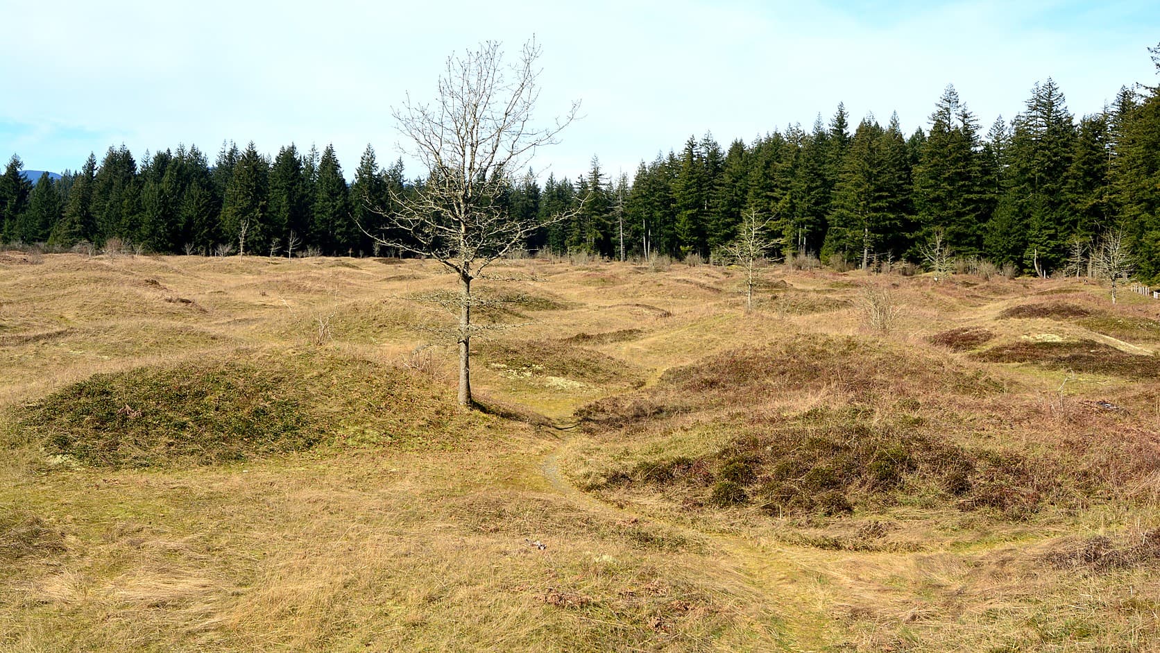
Mima Mounds in Washington: DNR says none of 30-plus theories is proven. Hours, Discover Pass, dogs, gunfire and the drive from Enumclaw, as of October 2026.
The Mima Mounds are low, round hills scattered across a prairie in Thurston County, south of Olympia and about 67 miles by road from Enumclaw. As of October 2026, the state's Mima Mounds Natural Area Preserve is open daily from 7 a.m. to dusk, parking takes a Discover Pass ($45 a year or $10 a day), and dogs are not allowed. What built the mounds is unsolved: the Department of Natural Resources (DNR) says more than 30 explanations have been proposed and none has been proven.
In 1841, by his own account, Charles Wilkes, who commanded the U.S. Exploring Expedition, took six men with shovels and picks to the prairie and opened three of the mounds to see whether they held relics. He found "a pavement of round stones" and nothing else. The explanations DNR lists run from pocket gophers to earthquakes to an ice-age flood that some researchers trace to a glacial lake near Mount Rainier.
What are the Mima Mounds?
DNR's sign at the preserve gives their size as roughly 8 to 40 feet across and up to 7 feet high, at about 8 to 10 mounds to the acre, and describes the soil as black, a mix of rounded gravel and sandy loam. In South Puget Sound they sit only on layered sediment that meltwater from the last ice sheet laid down. That ice sheet's final push into western Washington stopped about 16,500 years ago, and Mima Prairie lies at the edge of how far south it reached. DNR's page counts 756 acres in the preserve, forest and oak woodland included, and the Secretary of the Interior designated the site a National Natural Landmark in 1966. Lookalikes elsewhere go by other names, such as pimple mounds near the Gulf of Mexico and hogwallows in California, and the sign says each field may have its own origin.
How were the Mima Mounds formed?
No one has settled it. The sign puts the problem in one sentence: "More than 30 explanations have been proposed for the origin of the Mima Mounds, but none has been proven."
The earliest accounts offer theories too. Wilkes concluded that people had piled the mounds up, though not as graves, and dismissed a suggestion that water had made them. James Graham Cooper, working for the Pacific Railroad Surveys in 1853 and 1854, suggested eddies and whirlpools. The sign also relays a story told by Upper Chehalis people, printed in Thelma Adamson's 1934 collection, in which a great flood covers the world and, when the water falls, "the earth still remains in the shape of waves."
The scientific hypotheses start with pocket gophers, an idea Walter Dalquest and Victor Scheffer put forward in the 1940s: gophers digging nest chambers hit dense glacial debris and pushed soil and pebbles upward, so each mound is centered on one animal's territory. The sign says several scientists continue to work on it. In 1913 the geologist J Harlen Bretz made the first detailed study and suggested that gravel and soil washed onto melting ice might have collected in suncups, pits the sun melts into ice, and settled into mounds as the ice melted.
Others have proposed frozen ground (permafrost) cracking into many-sided shapes at the end of the ice age; shaking from earthquakes, an idea Andrew Berg put forward in 1990 (see Washington's biggest recorded earthquakes); sediment-rich floods from a glacially dammed lake; and meltwater runoff stripping soil from between trees and shrubs. A. L. Washburn favored that last one in a 1988 report published by DNR's geology division, but wrote that only future research would prove any explanation beyond doubt. Arthur Kruckeberg, a botanist the sign credits as an early advocate for protecting the site, put it this way: "Hardly any other land form has stimulated so much controversy in geologic and natural science."
Does Enumclaw's mountain have a part in the mounds story?
It may, by one hypothesis: the Washington Geological Survey's booklet on the mounds says some researchers think a flood broke out of Glacial Lake Carbon, a lake the ice dammed northwest of Mount Rainier, and carried volcanic rock from the Cascades to the prairies. It says mounds at Rocky Prairie, upstream, hold more and larger volcanic rocks than Mima Prairie's, though the flood's role is not yet clear. A 2002 conference abstract by a state geologist and a University of Puget Sound geologist called that flood a likely source of the mounds' sediment and put its ice-dammed lake in or beside the Carbon River valley, the river the old Carbon River Road follows into Rainier's northwest corner.
The ground itself differs. Enumclaw is built on the Osceola Mudflow, which came off Mount Rainier about 5,600 years ago by the U.S. Geological Survey's dating; Rainier is the closest of Washington's volcanoes to town. The state's geologic map puts City Hall on the mudflow and says it lies up to 75 feet thick on glacial drift, the debris glaciers leave behind. At the mounds' trailhead the same map shows gravel and sand deposited by meltwater from the retreating ice sheet.
How far is Mima Mounds from Enumclaw?
About 67 miles each way from central Enumclaw, a drive two routing engines put at roughly 85 to 100 minutes without traffic. The usual route runs west on SR 410, then SR 167, SR 512 and Interstate 5 south to exit 95. From the exit, DNR's directions run west on Highway 121 (Maytown Road SW) through Littlerock to 128th Avenue, then right on Waddell Creek Road; the entrance is about a mile along, on the left.
When is Mima Mounds open?
As of October 2026, DNR's page says the preserve opens at 7 a.m. and closes at dusk daily, and that the gate is locked outside those hours. DNR gives no clock time for dusk. By NOAA's solar equations, sunset at the trailhead is about 4:30 p.m. around December 21 and about 9:10 p.m. around June 21, and dusk follows it.
The hours have changed before. The Internet Archive's saved copies of DNR's page show 8:30 a.m. to 8:30 p.m. from April through September and 8:30 a.m. to 5:30 p.m. the rest of the year until February 2024, when an alert closed the preserve until May 1, 2024 because of extreme vandalism. By June 2024 the hours were 7:30 a.m. to 5 p.m. A second alert said that starting August 22, 2025, the preserve was "closed to the public until further notice due to ongoing vandalism"; summer hours of 8 a.m. to 5 p.m. were still listed. DNR reopened it on Monday, October 6, 2025, with the 7 a.m. to dusk hours, so a guide or search snippet that quotes an older schedule is out of date.
Do you need a Discover Pass, and can you bring a dog?
Parking at the preserve requires a Discover Pass, and dogs are not allowed, service dogs excepted, DNR's page says. The Discover Pass site lists the annual pass at $45 and a day pass at $10, with a $99 citation for a vehicle that does not display one. State law sets those prices; the annual pass rose from $30 on October 1, 2025, and the state's Office of Financial Management must review the prices every four years. Which pass works where near Enumclaw covers the other lots around town.
Why do you hear gunshots at Mima Mounds?
Because a target range sits next to the preserve. DNR's page says shooting and hunting are prohibited inside it and that "The firearm sounds you may hear on this site are occurring on the adjacent target range." DNR does not name the range. A hiker's report on the Washington Trails Association site names the Evergreen Sportsmen's Club and says it is closed Monday and Tuesday, so there is no shooting on those days. The club's address is on Marksman Road Southwest, a road DNR's geology booklet maps along the preserve's west side. In October 2026 the club's website listed Monday and Tuesday as closed, Wednesday, Thursday, Saturday and Sunday as 10 a.m. to 4 p.m., and Friday as rifle and pistol only.
How long is the walk, and when do the flowers bloom?
About an hour, by the geology booklet, which puts the trails at 3.3 miles in all; the Washington Trails Association lists a 2.75-mile round trip with about 10 feet of climbing. DNR's page describes a paved half-mile loop it calls ADA accessible and two longer gravel paths, with signs on geology, the mound theories, prairie ecology, fire and Native American use. On a clear day, the trails association's description says, Mount Rainier can be seen from the preserve; Mount Rainier viewpoints near Enumclaw lists closer ones.
DNR's flower sign calls camas the signature flower of the prairies and lists it among the early-spring bloomers. Prairie Appreciation Day, held on the second Saturday in May at the preserve and the nearby Glacial Heritage Preserve, is set for May 8 in 2027, its website says.
Before you go
Read the alert box on DNR's preserve page the morning you go, because that page, not an older guide, sets the hours and any closure. Bring a displayed Discover Pass, plan to be back at your car before dusk, and check the club's posted schedule if gunfire would spoil the walk. The trails association's listing says there is a toilet at the trailhead; DNR's page does not mention one. DNR asks visitors to report any sign of vandalism.
Story label: Original Story or Guide
Originally published: