

Feature
Foothills Trail from Enumclaw to Puyallup, every trailhead
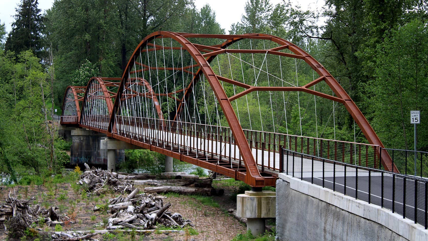
Foothills Trail from Enumclaw to Puyallup: about 24 paved miles, every trailhead and its parking, the rules, and the bridge work scheduled for late 2026.
The Foothills Trail runs about 24 miles from the south edge of Enumclaw to the East Puyallup trailhead at 13810 80th Street East, by Pierce County's count after its last gap closed in September 2025, and the whole length is paved, free to use and open from half an hour before sunrise to half an hour after sunset, as of October 2026. Dogs are allowed on a leash of eight feet or less, horses on a soft shoulder beside the Pierce County asphalt, and Class 1 and 2 electric bikes everywhere. From Enumclaw the trailheads come in this order: Warner Avenue and 252nd Avenue SE in Enumclaw, then Buckley, South Prairie, Orting, McMillin and East Puyallup.
The route has been usable end to end only since September 13, 2025. The $16 million bridge over the White River opened in September 2024 and joined Enumclaw to Buckley, but a wooden bridge over Spiketon Ditch, between South Prairie and Buckley, had been closed since November 2023 and torn down in June 2024 after inspections found it, in the county's words, "stressed under its own weight". The replacement opened eleven and a half months after the big bridge did, and the county's web pages have not all caught up: one still says the trail is expected to reach Buckley by 2006.
How long is the Foothills Trail, and do you need a pass?
Nobody agrees on the length, because nobody measures the same thing. Pierce County's Foothills Trail page calls its trail 22 miles from East Puyallup to the White River in Buckley, its extension page says 21, and its September 2025 notice for the Spiketon Ditch bridge opening described a continuous 24-mile stretch once the Enumclaw side was counted. The Washington Trails Association lists 21.0 miles one way, and King County's September 2024 news release 22 miles of uninterrupted paved trail. Add King County's mile from 252nd Avenue SE to the river and the paved mile the City of Enumclaw's 2019 parks plan lists at 2309 Warner Avenue, and about 24 miles is the honest figure. It is flat by local standards: the 2012 application that put the trail in the National Recreation Trail database gave a high point of 431 feet and a low of 59 for the 15 miles then built, and the county calls the rest a small climb.
Pierce County describes the surface as a 12-foot asphalt path for bicycles, walking, skates and wheelchairs, with a soft shoulder for horses, which must be walked across bridges. Neither county's trail page mentions a parking fee or a pass, and WTA lists the fee as none. Pierce County's trail rules page and chapter 7.12 of the King County Code, which governs the Enumclaw mile, agree on the rest: pets on a leash no longer than eight feet, Class 1 and 2 e-bikes allowed and Class 3 barred, and the trail closed from half an hour after sunset to half an hour before sunrise. Both counties also set a 15 mph limit and bar alcohol, and Pierce County's page spells out that electric motorcycles are not e-bikes and are not allowed.
1. Enumclaw: Warner Avenue to 252nd Avenue SE
The Enumclaw end is two pieces owned by two governments. The city's 2019 parks plan lists its own Enumclaw Foothills Trail as one paved mile at 2309 Warner Avenue, and the nine stainless steel elk stand on the trail where Warner Avenue meets SR 410. King County's mile, by its Foothills Trail page, begins at 252nd Avenue SE just south of town and follows the old railroad toward the river: the stretch to the Boise Creek bridge opened in the spring of 2021, the rest in 2024. The page describes no parking lot at 252nd, and we could not confirm one from the desk.
Near Boise Creek that last mile leaves the railroad. The trail follows the old Highway 410 alignment over Boise Creek and reaches Pierce County on what the county's page calls "three (3) abandoned highway piers", left when the highway moved downstream to the present bridge in 1949. Our history of the Northern Pacific through Enumclaw covers the railroad; Pierce County's trail history page adds that Burlington Northern abandoned the line in 1982, a coalition formed in 1984, the county council made the corridor a linear park by Ordinance 90-6 in October 1990, and construction began in 1998. In October and November the Boise Creek bridge is also the most reliable public spot near Enumclaw to watch salmon.
2. Buckley: the White River bridge and the SR 165 trailhead
The bridge is 572 feet of weathered steel on those three piers. King County's news release of September 30, 2024 says it opened the Saturday before, September 28, and that the $16 million project drew $12.8 million from the county parks levy. It is 16 feet wide and engineered for one emergency vehicle at a time. When a truck hit the SR 410 bridge in August 2025 and closed it for two months, the trail bridge became what King County's page calls a lifeline between the two towns, lit temporarily for round-the-clock use, with motorcycles and golf carts still barred. A creator's ride of those three flat miles during the closure is on this site.
On the Pierce County bank the bridge lands just north of 599 North River Avenue, and the trail runs through Buckley to the trailhead on the south side of SR 165 just off SR 410, with what the county's September 2025 notice called ample parking. The county's Buckley page is the stale one: "By 2006, the trail is expected to connect South Prairie into Buckley", it still says. From downtown Enumclaw the Buckley trailhead is about 4 miles by road.
3. South Prairie
The county's directions: SR 410 east 5.7 miles from SR 167 near Sumner, right on South Prairie Road East for 4.1 miles, right on Pioneer Way East. The county's page promises parking for 20 vehicles, a kiosk and a sani-can; its September 2025 notice put it more plainly: "Parking is very limited at South Prairie Trailhead". About a mile east is the Lower Burnett trestle, a 150-foot span over South Prairie Creek that replaced a railroad trestle removed in 1983, and about half a mile beyond it is the bridge that kept the trail in two pieces.
The Spiketon Ditch Bridge was built of wood in 2009 to match the railroad's look, by a county update of March 2025. An inspection in 2023 found progressive damage, the bridge closed in late November 2023, Bruce Dammeier, then the county executive, signed an emergency proclamation on May 28, 2024, and demolition began June 7. The News Tribune reported in April 2025 that the county had awarded a $1.084 million contract to Ceccanti Inc. for the replacement. The target slid from summer 2025 to fall after crews found unstable soil at the supports, and the ribbon was cut on Saturday, September 13, 2025, with County Executive Ryan Mello on the program.
WTA calls South Prairie to Buckley 4.3 miles; the county's notices, 1.5 miles to the Spiketon bridge and 4 more to Buckley, imply about 5.5. Past Buckley, the county's page for the Cascade Junction spur describes 1.3 paved miles and four bridges, rarely visited, it says, because access is difficult, with bridge damage since the spring of 2015 and a gate at the end: "Do not use the private road in this area." Everything beyond is closed to the public; the county's 2025 feasibility study found the old railbed from Wilkeson to Carbonado in good condition, and the county is seeking money for that 3.7-mile piece. From downtown Enumclaw the South Prairie trailhead is about 8 miles by road.
4. Orting
The Orting trailhead is in Orting City Park, off the main street downtown, with restrooms, a kiosk, a play area and, by WTA, parking for several vehicles. Orting to South Prairie is 7.5 miles by WTA, which matches the county's closure arithmetic of 9 miles from Orting to the Spiketon bridge and 1.5 from South Prairie; the county's segment page calls it almost 11. This is the stretch along the Carbon River, with eight bridges, four of them former railroad trestles, and crossings of South Prairie Creek, Voight Creek and Roush Creek. TrailLink calls it perhaps the only rail trail posted with lahar warning signs.
December 2025 floods closed the South Prairie Creek and Voight Creek bridges for debris from December 12 until inspections cleared them on December 18. And the city's Bridge for Kids, a pedestrian bridge over SR 162 built as a lahar evacuation route, has had the trail closed between Lane Boulevard NW and Old Pioneer Way NW since early 2025, with a detour along Old Pioneer Way that the county's notice said would last until spring 2026 and the city's project page until the bridge was done in summer 2026. The city's July 22, 2026 update said trail paving was finished and the bridge should "open to the public sometime in late September"; its September 3 update was still waiting on handrails, and as of October 14, 2026 it had posted no opening. From downtown Enumclaw the Orting trailhead is about 16 miles by road.
5. McMillin
The McMillin trailhead sits on the right just past the concrete bridge where the Puyallup and Carbon rivers meet, 2.2 miles short of Orting by the county's directions, with room for about 20 cars by WTA. The 2.3 miles from here to Orting were the trail's original Model Mile, the county says, and the section many consider the most scenic. The East Puyallup, McMillin and South Prairie trailheads were built to look like small train stations.
6. East Puyallup
The far end is at 13810 80th Street East, reached, by the county's directions, from the SR 162 exit off SR 410 at Sumner, half a mile south, then about a mile west on 80th Street. The county's notice of March 15, 2024 says the rebuilt lot reopened with 81 stalls, triple the old count, with signs, lighting and electric vehicle charging to follow that spring; the project page it linked to no longer exists, so we could not confirm those were installed. The first four miles toward McMillin run beside an active railway, the county's first rails-with-trail, and cross the tracks four times. From downtown Enumclaw the lot is about 16 miles and 28 minutes by road.
Is the Foothills Trail open? The work scheduled from late 2026
The next job is between Orting and South Prairie. The Ski Park Bridge there is a timber bridge built in 1904 as a railroad trestle, and the county's project page, updated in August 2026, says the design is done, the job is out to bid, construction is expected to begin in late 2026, and the trail will be rerouted along South Prairie Carbon River Road East rather than closed. Separately, the county warns that WSDOT's plan to rebuild the Rauch Creek culverts under SR 162 will bring temporary trail closures in 2024 to 2026; WSDOT's August 2025 fish passage bulletin listed that contract for advertisement in the first quarter of 2026, and we found no construction dates posted.
Before you go
Read the county's trail updates list the morning you go, and the City of Orting page if your ride passes through Orting. The hours are sunrise to sunset plus half an hour at each end, which in late December means a closing time a little before 5 p.m. The county's safety tips ask that you leave no valuables in the car at a trailhead, and the posted limit on the Pierce County miles is 15 mph. The county's trails planner, Travis Curry, is listed at (253) 798-4060.
Story label: Original Story or Guide
Originally published: