

Feature
Grays River Covered Bridge, built 1905, rebuilt 1988 to 1989
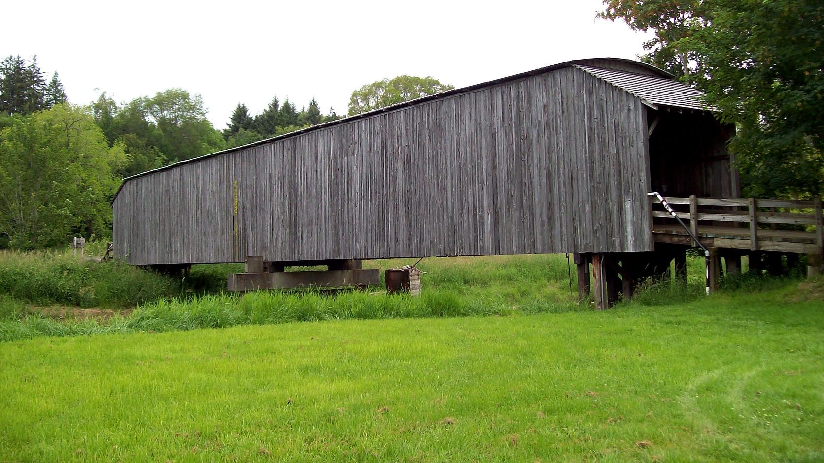
Grays River Covered Bridge in Wahkiakum County: built 1905, covered about 1908, rebuilt 1988 to 1989. History, who owns it and what to check before you go.
The Grays River Covered Bridge carries a one-lane road over the Grays River in western Wahkiakum County, just south of State Route 4 and 1.5 miles from the community of Grays River, on its east side. It was built in 1905 and roofed and sided about 1908. A 1991 federal engineering record called it the oldest covered bridge in Washington that is a functional part of a public highway system, and a 2006 HistoryLink essay repeated the claim. As of November 2026 no official page opened for this article says whether cars can cross it, so check before you drive there; the section on that question has what was found.
The surprise is that most of what you would be looking at is not 1905. Wahkiakum County, which owns the bridge, rebuilt it in 1988 and 1989, and HistoryLink says the project "essentially built a new bridge" to the old design. Inside the timber facade are steel beams. The county saved enough of the original cedar siding to cover one side, and left the other to weather.
Where is the Grays River Covered Bridge?
The bridge is in southwest Washington, in Wahkiakum County, about 11 river miles up from Grays Bay on the Columbia, by the 1991 federal record. That record places it on a road that meets Loop Road about 0.2 mile south of State Route 4, roughly 1.5 miles east of the community of Grays River. Wikipedia lists the road it carries as Covered Bridge Road and gives coordinates of about 46.355 north, 123.581 west.
From Enumclaw the route is long. OpenStreetMap routing, run on November 2, 2026, puts the drive at about 160 miles and three and a half hours without traffic. This is a day trip only for people who like to drive, and a better one when joined to something else on the coast, as the last section suggests.
How old is the Grays River Covered Bridge?
The bridge was built in 1905 at a cost of $2,615, by the figures in HistoryLink and the federal record, which both cite the county's weekly newspaper. The county commissioners authorized it after farmers asked. It is a Howe truss, which HistoryLink defines as a layout of timbers in which the top and bottom beams run parallel, joined by upright members and diagonals that form an X.
The cover came three years later. HistoryLink gives 1908 and the federal record gives about 1908. It was cedar siding laid in boards and battens, topped with a tin roof, so the structural timbers would stay out of the rain. Western Wahkiakum County is wet, and exposed wood there does not last. Porches with cedar shingle roofs were added at both ends in 1915.
The designer is a matter of belief. The federal record says the Astoria, Oregon, firm of Ferguson and Houston probably designed it, because the name appears on the 1905 plan. Much of the labor came from neighbors, whose work counted toward their county taxes, a common practice at the time.
Why was there a bridge here at all?
Because milk spoils. HistoryLink says there was no vehicle bridge across the Grays River before 1905. Farm wagons could ford the river only at low tide, since the lower Columbia's tides reach this far up. The steamboats that tied the valley to the outside world landed on the northwest bank, so dairy farmers on the southeast side had trouble getting perishable goods to market.
Hans P. Ahlberg, a Swedish immigrant who founded the Grays River Grange in 1901, led the push, and the bridge stands on land he owned, below his homestead. A grange is a local chapter of the farmers' organization the Patrons of Husbandry.
The plateau has the same story. Enumclaw turned to cows once its hop boom collapsed in the 1890s, as Enumclaw's dairy history explains, and the Grays River valley's economy rested on the same animals. By the 1991 federal report, the valley's "once handsome, but now neglected" dairy barns testified to the industry's decline. The bridge outlived much of what it was built to serve.
Is it the original bridge?
Not in any way that counts as structure. A 1987 county inspection, by the federal record, found dry rot and a load capacity of five tons, too low for farm trucks. Wahkiakum County chose to rehabilitate rather than replace, helped, the record says, by local sentiment and by the approach of Washington's 1989 centennial; the state had entered the Union 100 years earlier, as when Washington became a state explains. The county awarded a $295,980 contract to Dulin Construction of Centralia on August 23, 1988.
The result was a two-span steel through-truss, rated to carry a 15-ton truck. Its portal beams are steel, covered by a timber facade two inches thick, so they look like the old timbers. Workers reused what they could, and the salvaged cedar covers the downstream face, the side most visible to travelers. New cedar on the upstream face was expected to weather to match.
The work was substantially finished on September 28, 1989, and the rededication was held two days later, on September 30. A county newspaper said of the rebuilt bridge, in words the federal record quotes, that "it is expected to function throughout the twenty-first century."
If you like bridge records, the same federal program, the Historic American Engineering Record, is a source for some of the engineering in the Tacoma Narrows Bridge collapse timeline.
Is the Grays River Covered Bridge still open to cars?
Two published histories say it carried traffic when they were written, and no official page opened for this article says what its status is in November 2026. The federal record, dated 1991, lists its use as a vehicular bridge and says it "continues to serve as an important link in the local transportation system." HistoryLink, in 2006, made the same age claim and described it as still carrying a public highway. In their own words both call it the oldest, not the only one; the federal record does quote a 1989 newspaper calling it the only one in use on a public road, and Wikipedia says the same, but this page does not repeat that.
A Wahkiakum Chamber of Commerce visitor page, undated, says the bridge "is still used everyday." The county's own Public Works page, read on November 2, 2026, lists no notice about the bridge. A county page is not a statement of status, and a bridge this old gets closed for repairs from time to time; the county has the authority and the phone number, 360-795-3301, at the Public Works office in Cathlamet, which lists weekday hours of 8 a.m. to 4 p.m.
The height and weight limits were not found either. The rehabilitated bridge was built to a 15-ton loading, and the original had 16.75 feet of clear height inside the cover, by the federal record, but a posted sign governs.
Who looks after it now, and what is the Covered Bridge Dinner?
The county owns the bridge, by the federal record and HistoryLink. Wikipedia, citing the Wahkiakum Eagle, says the Grays River Grange has managed Ahlberg Park, the bridge's surroundings, since 2011. The park's name honors the family that homesteaded there, by a 2007 Daily Astorian report; I did not find a Grange or county page that describes the park today, its hours or any parking.
The best-documented event is a meal on the bridge itself. Washington State University's Wahkiakum County Extension says its 19th annual 4-H Covered Bridge Dinner was set for October 3, 2026, at 4:30 p.m., with local food "served on the Grays River Covered Bridge" and an auction, to raise money for 4-H youth. The rule behind the date: the extension office says tickets go on sale each year on August 1 or the next business day, in person at its Cathlamet office, cash or check only. The page gives no date for a 2027 dinner. That makes early October the usual pattern, not a promise.
HistoryLink also says the bridge's festival became annual after 1989. A Chamber page lists a Covered Bridge Festival in August, but no current date was found, so do not plan around one.
Before you go
Check three things. First, call the county Public Works office, or look at its alert pages, to learn whether the bridge is open to vehicles and what limits apply; Wahkiakum County's website carries the department's contact details. Second, if you intend to walk or park, ask the Grays River Grange about Ahlberg Park, because no source opened for this article states hours or rules. Third, check the weather: this corner of Washington is wet, and the river here rises and falls with the Columbia's tide.
The southwest corner has other stops that ride along with a long drive. The Long Beach Peninsula's bogs are covered in the Washington cranberry harvest guide, and Washington lighthouses you can visit includes Cape Disappointment. Neither is next to the bridge, and each has its own calendar.
For the history, read the HistoryLink essay first, which is the clearest account of the 1905 bridge and the 1989 one, then the federal engineering record. The dinner details are on the WSU Extension Wahkiakum County page.
Story label: Original Story or Guide
Originally published: