

Feature
Mount Baldy and the 1895 eruption report in Enumclaw
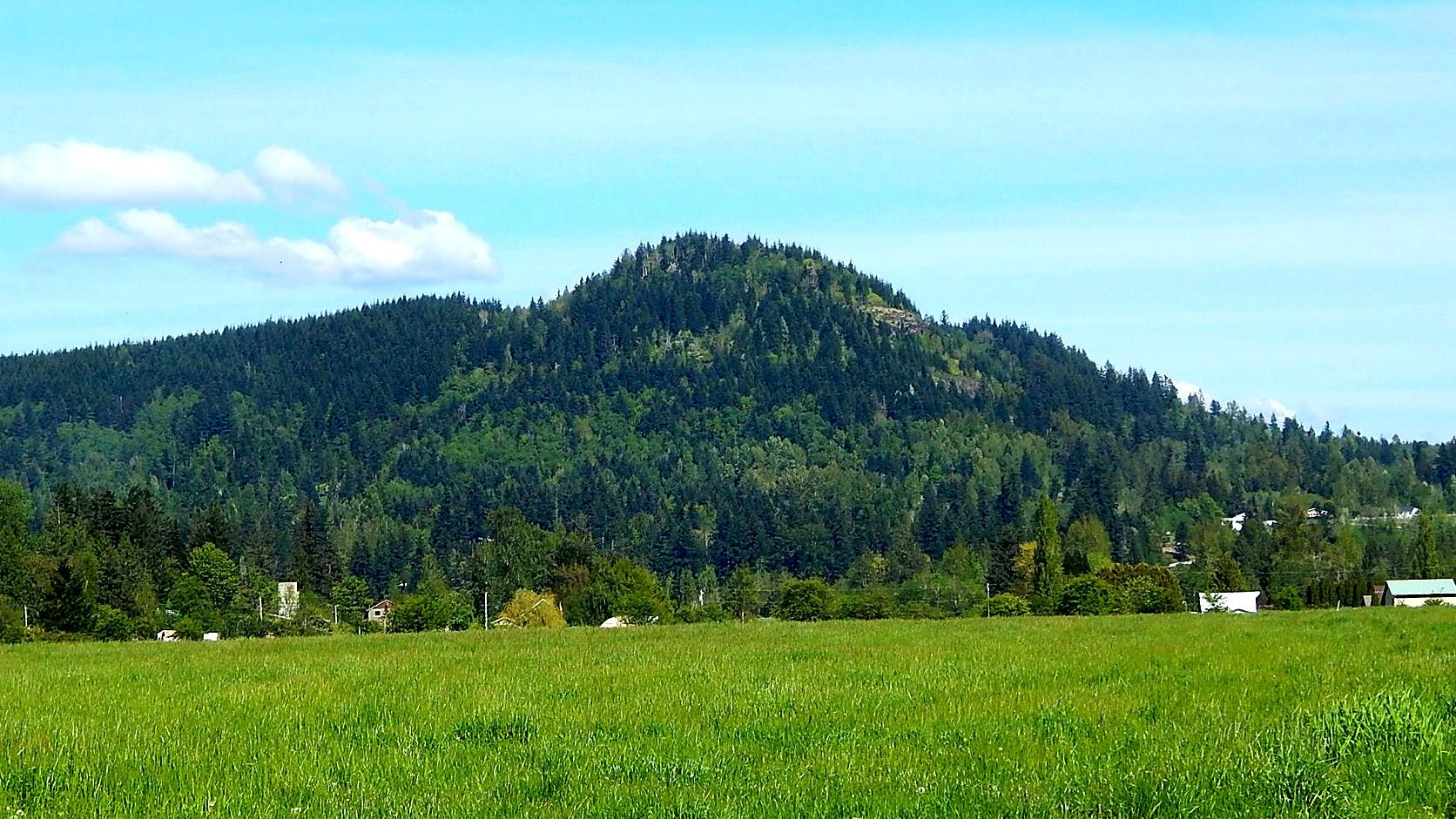
Mount Baldy above Enumclaw was reported erupting in January 1895. What the Buckley Banner said, what is known, and why no source can name the cause.
Mount Baldy, which HistoryLink says rises above Enumclaw and which this article takes to be today's forested Baldy Hill southeast of town, was reported to have erupted in January 1895, and nobody has shown what actually happened. The report comes from the Buckley Banner, a newspaper in the neighboring town of Buckley, in an issue dated January 11, 1895, as the HistoryLink history of Enumclaw cites it. A 1998 HistoryLink timeline entry on the story, since removed from the site, called the event "geologically unlikely and otherwise unconfirmed," and no source opened for this article names a cause.
The part that makes it worth a second look is the quiet. HistoryLink writes that Enumclaw's promoters said nothing about it and kept the "eruption" out of their promotional booklets. The paper described explosions like cannon fire, and, by HistoryLink's account, the promoters stayed silent.
Did Mount Baldy erupt in 1895?
Nobody can say, and the sources do not agree on what kind of event it was. What exists is a reported newspaper account, known only through HistoryLink's two retellings of it. HistoryLink dates the report to 1895. HistoryLink's essays on Enumclaw and on the report were written in 1998.
The date is slightly loose. HistoryLink's Enumclaw history puts the Banner article on January 11, 1895. HistoryLink's separate timeline entry is titled with January 10, 1895, yet its own source line lists the Banner of January 11. The Banner issue itself was not found for this article, so the two dates stay unresolved.
What did the Buckley Banner report?
According to HistoryLink, the Banner described the hill as "boiling and sputtering," with explosions "like the roar of a cannon" and a "crater alive with a terrible heat." Those are HistoryLink's quotations of the paper; the Banner page was not available for this article, so the wording is secondhand.
The timeline entry adds more color, in its own words rather than the paper's. It said the event was portrayed with molten lava running down the slopes and smoke visible from as far away as Seattle, which it put about 50 miles to the northwest. It set that against its own caution, "geologically unlikely and otherwise unconfirmed." That is the best summary available: a vivid story, no confirmation, and a source that said so plainly. As of November 2026 the timeline entry is no longer on HistoryLink's live site and survives in the Internet Archive's copy of May 2016.
HistoryLink cites two sources for the report: the Banner and pages 92 and 93 of Nancy Irene Hall's 1983 local history, In the Shadow of the Mountain, published by the Courier-Herald. Hall's book was not opened for this article.
Where is Mount Baldy in Enumclaw?
It is the wooded hill just southeast of town, and every source places it a little differently. HistoryLink's entry, which dates its own text to 1999, says it looms over the King County Fair Grounds on Enumclaw's east side. A photographer who posted it to Wikimedia Commons describes Baldy Hill as southeast of Enumclaw, seen from 268th Avenue Southeast, at an elevation of 1,664 feet. The climbing site SummitPost, which carries the same elevation, says it sits just east of town off Highway 410, and places a parking area 2.5 miles east of Enumclaw on that highway.
The name is a small puzzle too. The Banner's "Mount Baldy" is taken here to be the hill mapped and photographed as Baldy Hill, because it shares the name and HistoryLink places it above the town. No source says so in as many words.
Is Mount Baldy a volcano?
The rock under it is volcanic, but very old, and no mapped vent turned up. The Washington Geological Survey's statewide 1:100,000 geologic map, which the Department of Natural Resources serves online, shows the ground at the coordinates SummitPost lists for the hill as the Fifes Peak Formation. The survey describes that unit as lava flows, tuffs and breccias, a breccia being rock made of broken angular fragments, and gives its ages as roughly 16 million to 25 million years. Those are rocks millions of years old, not a recent flow. The same map unit is on Mount Peak, the hill south of town in this site's guide to its lookout.
The state's vent layer for the same map, searched across the area around Baldy for this article, listed none. That does not rule anything out, and it does not explain a report from 1895. Old volcanic rock under a hill is one thing; a fire or explosion on it in the winter of 1895 is another.
Why did Enumclaw stay quiet about it?
HistoryLink gives no reason. Its two essays describe local promoters, and in the timeline entry the Northern Pacific Railroad too, as playing down the area's potential for volcanic disaster. The plateau's hop boom had ended with lice and falling prices, in HistoryLink's account, and farmers were turning to dairy. The Northern Pacific, by the same account, also bypassed the town with a cutoff through Palmer.
The motive is easy to guess, and nothing opened for this article states it. No promotional booklet was opened either.
One more detail from the same essay: it repeats a legend that the name Enumclaw comes from a native word for a roar of thunder out of a nearby mountain. HistoryLink's timeline entry called that ironic beside the Banner's account. It is a legend, and nothing here connects it to Baldy.
Was Mount Rainier smoking that winter?
Yes, and that may be the setting the Baldy report was printed into, though no source links them. The Pacific Northwest Seismic Network's historic catalog transcribes a 1935 paper by Donald Bradford on Mount Rainier in late 1894. It describes smoke reports from Seattle people on November 21 and from a Weather Bureau observer on December 13, and an expedition sent by the Seattle Post-Intelligencer. According to the pigeon message the expedition sent on December 26, the change seen on the mountain was due principally to "tremendous avalanches and not to an eruption." The Post-Intelligencer's full report ran on January 6, 1895, five days before the Banner date.
So Seattle readers had weeks of volcano talk when the Baldy report appeared, and that explanation was already being offered for Rainier. Nothing in the catalog mentions Baldy, and the U.S. Geological Survey's Cascades Volcano Observatory page of historical newspaper clippings has no Baldy entry either. Whether the Banner was reporting something real, repeating rumor or reacting to the volcano talk of that winter is not something these sources can answer.
Is Enumclaw at risk from volcanoes?
The real volcano is Mount Rainier, not Baldy. The U.S. Geological Survey's hazard maps are the place to look, and this site has set out what they say about Enumclaw and the lahar zone, where lahars are volcanic mudflows. It has also covered the volcanoes on Washington's threat list. The flat ground under the town owes its shape to an old Rainier mudflow, told in the guide to the flat part of town. Nothing found for this article suggests any hazard from Baldy.
Why the story is hard to check
The Banner was a Buckley paper. This site's history of the Courier-Herald says Enumclaw's own paper has reported on the town since July 1900, five years after the Banner report. The one local telling HistoryLink points to is Hall's 1983 book. Anyone who wants to settle it needs the Banner issue, and the book's pages 92 and 93. A library that holds Washington newspapers is the likely place to ask; none was contacted for this article.
Before you go
As of November 2026, no official park, trail or access listing for the summit of Baldy Hill turned up. SummitPost, an undated site written by climbers, says the true summit is private land whose owners prosecute trespass, and that legal foot travel, by permit according to a 2012 note on that page, stays on the north side of the hill. This desk could not confirm ownership or access from a county or landowner record, so treat it as a hill to look at from public roads, not climb. The photograph on this page was taken from 268th Avenue Southeast.
Before any visit, check the King County parcel map for who owns a given piece of ground and look for signs on the spot. The rule behind it is simple: on private land the owner decides, not a website. For the geology, the Department of Natural Resources publishes its geologic map online. For the 1895 record, ask a library that holds Washington newspapers whether it has the Buckley Banner of January 1895.
Story label: Original Story or Guide
Originally published: