

Feature
Nisqually National Wildlife Refuge hours, tides and the fee
Nisqually National Wildlife Refuge hours, the $3.00 fee per four adults, four tide bands, five stops and a hunt-season closure to check, as of October 2026.
Billy Frank Jr. Nisqually National Wildlife Refuge, called the Nisqually National Wildlife Refuge until Congress renamed it in December 2015, sits on the Nisqually River delta, the low ground where the river meets Puget Sound, at Interstate 5 exit 114, about 43 miles by road from Enumclaw City Hall. As of October 2026 the grounds are open daily from sunrise to sunset, the visitor center is open 9 a.m. to 4 p.m. Wednesday through Sunday, and the refuge's visit page sets the entrance fee at $3.00 per four adults, with children under 16 free, in cash or by check only. The tide decides what the boardwalk shows, and its outer end has been closed in waterfowl hunt season, which the refuge puts at October to January.
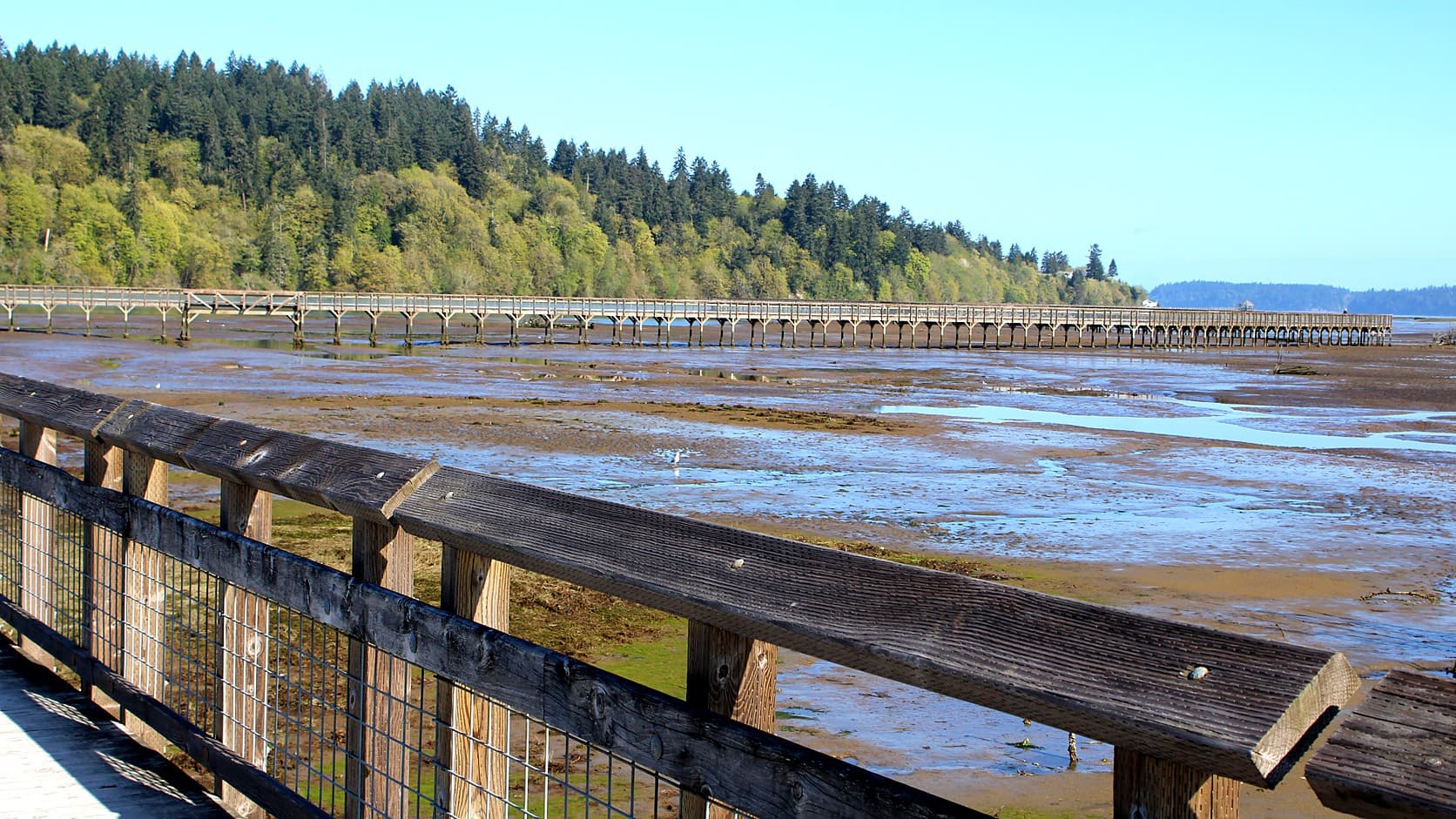
Until 2009 a century-old dike kept the tide off farmland on this delta. That year the refuge, the Nisqually Indian Tribe and Ducks Unlimited took out the Brown Farm Dike, and the tide returned to 762 acres. The boardwalk, which opened on February 1, 2011 to let visitors walk into the restored area, reaches out as far as the dike did, the refuge's timeline says.
What does the tide change at Nisqually National Wildlife Refuge?
The tide decides whether the boardwalk looks out on mud or on water, and the refuge sorts it into four bands. Its visit page says: "Tides of 10 feet or less: Lots of mud is exposed. This is good for herons, shorebirds, and dabbling ducks. Tides 10-11 feet high: Tides cover most of the mudflats around the Estuary Boardwalk. This is good for dabbling ducks." Dabbling ducks, such as the mallards and wigeon the refuge lists, feed at the surface or tip up in shallow water instead of diving.
For the higher tides, the page says: "Tides 11-13 feet high: Some woody debris can still be spotted on the mudflat, but the water is deeper. This is good for diving ducks and seabirds. Tides over 13 feet: Lots of water is around the Estuary Boardwalk. This is good for diving birds."
The page gives heights but names no gauge, and it points to a private tide-table site. NOAA's predictions for Dupont Wharf, Nisqually Reach, its nearest tide-prediction station to the refuge, are the official numbers. They list 705 low tides for 2027, every one below 10 feet, and 706 high tides, 334 of them above 13 feet. If the refuge's heights match NOAA's, the mud band returns about twice a day and the water band on nearly half the high tides.
1. Norm Dicks Visitor Center
The visitor center is the refuge's suggested starting point, open 9 a.m. to 4 p.m. Wednesday through Sunday, excluding federal holidays. Volunteers help plan a visit and share recent wildlife sightings, a viewing platform outside overlooks the permanent wetland, and binoculars can be borrowed with a photo ID, the refuge says. The fee kiosk is near the visitor center's entry, and restrooms are across from the center. Volunteer-led walks, listed on the refuge's events page, leave from the observation deck beside it. A bald eagle nest taken from an Orcas Island tree in 1994 went on permanent display inside in October 2026, a refuge story says. The five stops follow the order in which the refuge's trail descriptions link them, not a ranking.
2. Twin Barns Loop Trail
The refuge's trail list puts the loop at 0.89 mile, and its visit page suggests it for an hour's walk after the visitor center. The west side, from the second parking lot, is boardwalk past ponds and wetland; the east side runs through forest the tide influences, with spurs to a river overlook and deeper into the trees. The barns date from 1932, the refuge's timeline says, replacing barns that burned in 1929. A packed-gravel road listed as the 0.67-mile Road to Twin Barns Trail runs straight to the barns, and the refuge says the freshwater wetland along its west side offers great waterfowl viewing in winter.
In December, the refuge says, it is not unusual to see 4,000 to 6,000 wintering geese and waterfowl across its seasonal wetlands, pastures and estuary. Its birding page lists cackling geese, green-winged teal and American wigeon among the winter species present in very large numbers, though variety peaks in spring and fall migration. Reports posted to the Tweeters birding mailing list on the weekly Wednesday walk counted 71 species on January 8, 2025, with a barn owl at the Twin Barns Overlook, and 74 on January 14, 2026.
3. Nisqually River Overlook Trail
The overlook is a 0.08-mile spur with two ways in, the Twin Barns Loop and the Nisqually Estuary Trail, and it ends at a view of the river with benches and viewing scopes. In salmon season, the refuge says, fish may be seen moving upstream with harbor seals and other predators behind them. Its winter notes put a peak of chum salmon in the river, with bald eagles posted along it and on the delta to take advantage of low tides and concentrated fish, the pairing this site describes for the Skagit River's winter eagles.
4. Nisqually Estuary Trail
The Nisqually Estuary Trail is a 0.59-mile packed-gravel levee that links the Twin Barns Loop to the boardwalk, with the estuary on one side and freshwater wetlands on the other. The refuge rates it easy, about 30 minutes. It has no shade, and the refuge keeps benches off it so that its vehicles can pass. The trail list tags this trail, the boardwalk and the river overlook as kid friendly and wheelchair friendly.
5. Nisqually Estuary Boardwalk
The boardwalk is the long walk over the flats: the refuge lists it at 1.05 miles, and a refuge story from August 2025 gives 5,539 feet. A covered shelter with viewing scopes stands at each end, and the refuge warns of wind and exposure. The refuge's "4-mile round-trip" figure from the visitor center fits: its 2011 opening notice put the start of the boardwalk a mile from the center. On a clear day the walk can show Mount Rainier and the Olympic Mountains, the refuge says, and sea ducks and seals depending on season and tide; the Rainier viewpoints guide covers where else to see the mountain from Enumclaw.
Winter is the catch. The refuge's January 2011 notice on the new boardwalk trail said that after February 1 the trail would be open every day from sunrise to sunset "with a partial seasonal closure during the waterfowl hunt season from October to January." A walk report posted to the Tweeters list on January 15, 2026 said the end of the boardwalk was scheduled to reopen on Monday, February 2, 2026. The refuge's visit, trail and rules pages, read on October 21, 2026, mention no closure and give no dates, and the state sets hunt dates each year; the refuge lists the 2026 goose and duck season as October 17, 2026 to January 31, 2027. Call (360) 753-9467 before counting on the outer end.
How big the restoration it crosses was depends on who is describing it. The refuge's pages call the 2009 removal of the Brown Farm Dike the largest estuary restoration in the Pacific Northwest, and the U.S. Geological Survey calls it one of the largest. The then president of the refuge's friends group said in written testimony to a House appropriations subcommittee in 2020 that it was the largest on the West Coast. The refuge counts 762 acres, while Ducks Unlimited, a partner, counts more than 900 once 140 acres the Nisqually Indian Tribe restored earlier are added.
Is there an entrance fee, and what are the rules?
The refuge charges one, and its visit page is blunt about how: "The daily entrance fee is $3.00 per four adults and children under 16 years are admitted free. We can only accept cash or checks, not credit cards." Payment goes in a blue envelope into a canister at the kiosk; keep the tear-off receipt with you on the trails. As of October 2026 the refuge honors America the Beautiful passes, which admit the pass holder and three more adults, and sells a $12 annual pass good only there; the Washington Discover Pass is not accepted, and this site's pass-by-pass guide covers the other parks near town. Most fee money returns to the refuge for visitor programs, it says. The Fish and Wildlife Service lists October 27 and November 11, 2026 as fee-free days at refuges that charge a fee and posts them on its events pages.
The refuge's home page warns of "special rules here: no pets, no jogging, no recreational wheels like bikes or scooters, no drones" and its rules page spells them out. The ban on pets, dogs included, starts on the entrance road, and pets may not be left in vehicles; only leashed, fully trained service animals are welcome. Wheelchairs and baby strollers are the only wheeled equipment allowed on the trails, and cyclists who arrive by road can use a rack across from the visitor center. The page adds that this is not a park for ball games, kites, ham radios or balloon-and-barbecue parties.
What does the Nisqually delta have to do with Enumclaw?
The Nisqually River begins in the meltwater of Mount Rainier, the U.S. Geological Survey says, and ends at this delta; this site's viewpoints guide puts the summit about 27 miles from Enumclaw City Hall in a straight line. A state task force's July 1972 report, titled The Nisqually Plan: From Rainier to the Sea, called for a federal refuge in the delta, the refuge says, and one followed in 1974.
The closer tie is a treaty. Public Law 114-101 renamed the refuge on December 18, 2015 for Billy Frank Jr., a Nisqually tribal member who died in 2014, and created the Medicine Creek Treaty National Memorial inside it, to mark where the 1854 treaty was signed; the law names the Muckleshoot, Nisqually, Puyallup and Squaxin Island tribes, and the U.S. Geological Survey counts nine tribal nations among the signers. This site's profile of the Muckleshoot Indian Tribe places its reservation between Auburn and Enumclaw. None of the refuge pages read for this guide says whether visitors can see the signing site, so it does not send you there.
How far is it from Enumclaw, and what should you check first?
By two routing engines the refuge is about 43 miles and about an hour from Enumclaw City Hall without traffic: State Route 410 west, State Route 167 south, State Route 512 west, then Interstate 5 south to exit 114, the exit the refuge's directions name. Two lots hold 97 parking spaces in all, a refuge story from July 2026 says.
Check the visit page or call (360) 753-9467 for alerts and the status of the boardwalk's end, and bring cash or a check. The gate opens and closes on a schedule, the rules page says, and visitors should leave before it shuts; in December, by NOAA's solar equations for the refuge's coordinates, sunset falls between about 4:20 and 4:30 p.m., within half an hour of the visitor center's 4 p.m. close. The refuge asks for caution in fall and winter, when wet leaves litter the trails and temperatures can reach freezing; staff blow the leaves and sand the boardwalks. Hunting on the delta is by boat only, and the trails lie in a sanctuary closed to hunting; the Skagit Valley snow-goose guide covers the same overlap of hunting and viewing elsewhere. The trail list also names a Hoffman Hill Trail, 0.57 mile, with no description, and this guide does not cover it. The Northwest Trek guide has the hours and prices of another day trip from Enumclaw.
Story label: Original Story or Guide
Originally published: