

Feature
Peace Arch State Park at Blaine, hours, fee and ID rules
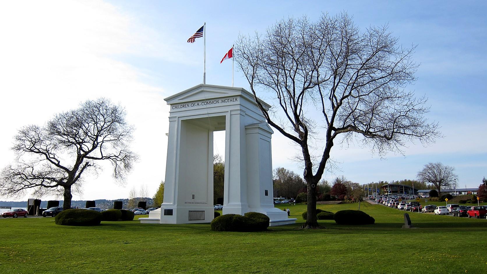
Peace Arch State Park in Blaine is open 8 a.m. to dusk, takes a $10 Discover Pass and is pass-free Nov. 11, 2026. Hours, ID, history and the border.
Peace Arch Historical State Park in Blaine, Washington, is open from 8 a.m. to dusk every day of the year, and a vehicle needs a Discover Pass to park there: $10 for a day or $45 for a year, as of November 2026, according to Washington State Parks. The pass is not needed on Wednesday, November 11, 2026, which the state has named a Discover Pass free day for Veterans Day. The park is day use only, and dogs must be on a leash. What the border agencies expect of a visitor is a separate question, and it gets its own sections below.
The arch itself is the oddity. It is a 67-foot concrete monument that straddles the line between Washington and British Columbia, and the iron gates inside its portal are permanently held open, by HistoryLink's account, and BC Parks says they were left open to symbolize peace. The inscription on the east wall reads "May These Gates Never Be Closed." November 11 is also the day Washington became a state in 1889, so the free day falls on statehood day as well as Veterans Day.
What are the Peace Arch State Park hours?
The Washington State Parks page for the park lists the hours as 8 a.m. to dusk, year round, and the alerts box on that page, read on November 2, 2026, carried only a Level 1 burn-ban notice: fires allowed in designated pits and grills, and propane and gas grills allowed. There was no closure notice. The park's row on the State Parks winter schedule page lists no seasonal closure dates. Dusk comes early in November, and the time changes daily, so check sunset for the date you go.
The state park is the southern half of a pair. British Columbia Provincial Parks runs the northern half, and its page says the parking lot on the Canadian side can be used only while the park gate is open, 8 a.m. to 8 p.m. daily, as read on November 2, 2026. That lot is on Semiahmoo First Nation land, which BC Parks subleases for public use.
How much does Peace Arch State Park cost?
The State Parks page says a Discover Pass is required for vehicle access, and sells one-day and annual passes at automated pay stations on site. The Discover Pass page lists $10 for the one-day pass and $45 for the annual pass, with transaction fees possible. One annual pass can cover two vehicles, though it is valid for only one at a time.
Two rules sit behind those numbers. State Parks posts the price on its Discover Pass page, so check that page on the day you go. And State Parks announces each year's free days in November for the year after. State Parks and its sister agencies released the 2026 list of 12 days on November 12, 2025, and the State Parks release lists Wednesday, Nov. 11, as the Veterans Day free day. The Discover Pass page adds that free days cover day-use parking only. Which agency wants which pass around Enumclaw is in the guide to which pass you need near Enumclaw.
Do you need a passport to visit Peace Arch Park?
No agency page opened for this article says a passport is required just to enter the park, but you may be asked for identification once you are inside. The International Peace Arch Association, a private nonprofit that looks after the park's heritage and is not a government agency, writes that "Your passport or I.D. is NOT required to enter the international park by Washington State Parks & British Columbia Provincial Parks." It adds that four agencies watch the park, among them U.S. Border Patrol and the Canada Border Services Agency, and that anyone asked must show photo ID. It also says resident aliens and visa holders are required by law to carry their papers, including in the park.
The government side says something similar and shorter. British Columbia Parks, a provincial agency, tells visitors on its page: "You may be asked to provide identification and immigration information by officers of the Canada Border Services Agency or U.S. Customs and Border Protection." Bring government photo ID.
Can you walk from Canada into Peace Arch State Park?
Not by any rule this article can confirm, so treat the answer as unsettled and ask the agencies. Cascadia Daily News wrote in May 2024 that Americans and Canadians had traditionally used both halves of the park without going through a crossing, as long as they returned to the side they came from, and HistoryLink's 2009 essay described a similar custom as of 2009. Neither is a rule in force, and this article is not advice to cross the line inside the park.
In that same May 2024 report, a U.S. Customs and Border Protection public affairs specialist said Canadians could no longer enter the park from 0 Avenue in South Surrey and had to come through the Canadian park. The report said they were not permitted past the restrooms on the American side, and that anyone wanting the "upper state park area" had to use the border crossing and be inspected. CBP tied the change to a rise in illegal crossings around the park. This article could not open any CBP or CBSA page that states the rule on the day it was written, so whether the 2024 limit still holds is unknown here.
Nothing opened for this article says the park is a way into either country, and entering one is done at a port of entry. CBP's page for the Blaine port lists 360-332-5771, and the Peace Arch Association lists CBSA at 1-800-461-9999. Call before a trip that touches the line.
Who built the Peace Arch, and when?
Sam Hill, a lawyer, financier and road builder, financed and directed it, and he dedicated it on September 6, 1921, which Washington State Parks calls the world's first shrine to peace. HistoryLink says work began in July 1920 and that the structure took 50 tons of steel plus 800 cubic yards of poured concrete. Hill founded the Washington State Good Roads Association, and a motion at the 1915 Pacific Highway dedication at the border asked both governments to build a peace arch.
The two sides carry different inscriptions. HistoryLink reports "Children Of A Common Mother" above the portal on the American side, and a different line on the Canadian one. Inside, the west wall carries a dated reference to the century of peace from 1814 to 1914. State Parks says the 1814 Treaty of Ghent started a process that the 1842 Webster-Ashburton Treaty and the 1846 Oregon Treaty carried on; the Pig War guide covers what the 1846 treaty left unfinished in the islands.
What is there to do in the park?
The grounds are lawns, formal gardens and picnic ground. State Parks counts 79 unsheltered picnic tables, first come and first served, plus a playground with a swing set and play field, horticultural displays, and interpretive panels with audio. The American Kitchen, a day-use building, can be rented, and bird watching is listed.
The gardens have a documented backstory. In 1930 the state's superintendent of public instruction approved a fund drive among schoolchildren, and State Parks says they gave about $1,200 in pennies and nickels. HistoryLink gives the children's sum as $1,500. The sources disagree on the figure, and both agree the money went to landscaping. State Parks says the formal gardens hold more than 10,000 annuals planted each year by park staff.
Dogs are allowed on a leash and horses are not. State Parks lists the American side as day use only, and BC Parks does not allow camping anywhere in the park.
How far is Peace Arch State Park from Enumclaw?
About 145 miles by road, roughly three hours and eight minutes without traffic, by the Open Source Routing Machine, a mapping service built on OpenStreetMap data, measured from Enumclaw City Hall to the coordinates on the State Parks page. The IPAA says drivers coming from the American side should use Exit 276 off I-5, and warns that a phone's GPS can send a car into the border queue instead of the park, so turn it off near the area.
The Skagit Valley lies along I-5 on the way north. When snow geese reach the Skagit Valley covers stops on the delta, where to see bald eagles on the Skagit River covers the river upstream, and Deception Pass State Park is on SR 20 west of the interstate.
What is the local connection?
Washington became the 42nd state on November 11, 1889, Enumclaw.com's guide to when Washington became a state explains, and the state's land agencies named the same date a free day in 2026, for Veterans Day. HistoryLink writes that an International Armistice Day observance begun in 1937 grew into the annual Hands Across the Border celebration at the arch, and its 2009 essay put that on the second Sunday in June, a date not rechecked here. The park itself was landscaped as Depression relief work, with thirty men hired for two days each, State Parks says.
Before you go
Check the State Parks page for Peace Arch Historical State Park on the morning you leave, since its alerts box is where closures and burn-ban changes appear, and confirm that November 11 is still listed as a free day on the Discover Pass page. On any other day, buy a pass at the pay station. Check sunset, carry photo ID, and leave the border question to the agencies: CBP at 360-332-5771, CBSA at 1-800-461-9999. The park's own number is (360) 332-8221, and its address is 19 A Street, Blaine, WA 98230.
Story label: Original Story or Guide
Originally published: