

Feature
Snoqualmie Falls parking, the hike and the flow rate
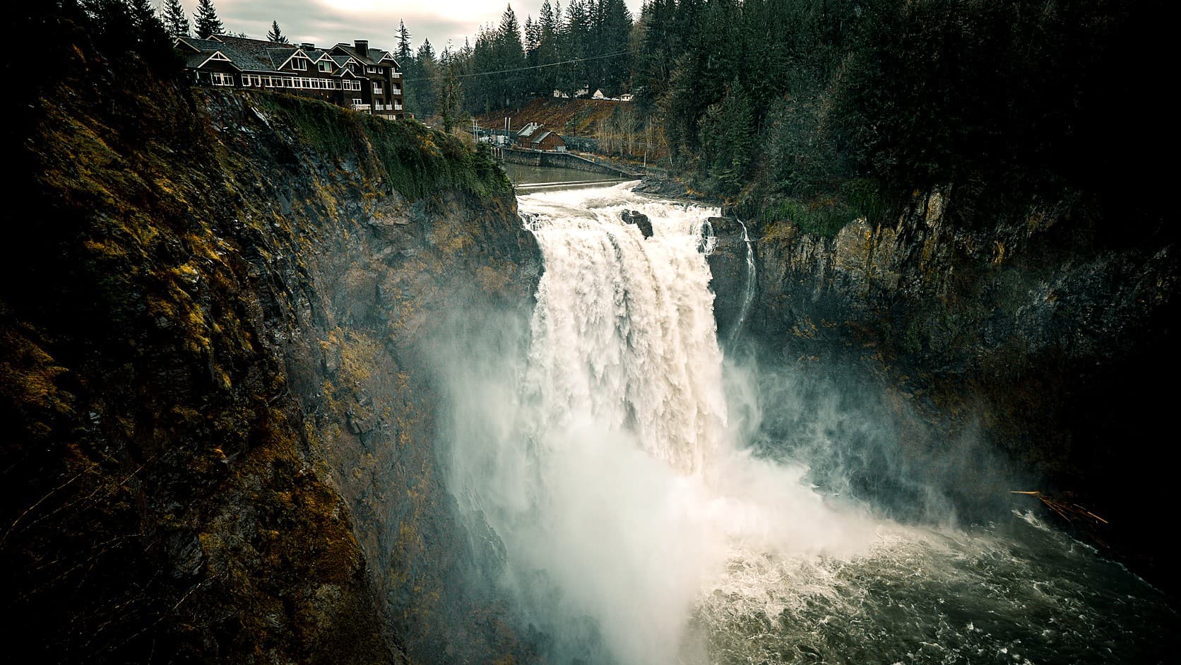
Snoqualmie Falls parking: which two lots are free, the 1.4-mile hike to the river and back, and the USGS gauge that shows how big the river is running.
As of October 2026, two of the three parking areas at Snoqualmie Falls are free on Puget Sound Energy's own park map: the large upper lot across State Route 202, joined to the park by a footbridge, and the lower park lot on SE Fish Hatchery Road. Only the small gift-shop lot beside the viewpoints charges. The trail to the river is 0.7 mile each way with 250 feet to climb back, by the Washington Trails Association's figures, and the falls are about 31 miles north of Enumclaw, roughly 52 minutes by SR 169 and SR 18.
The falls themselves have a legal minimum, and most of the year it is small. PSE's federal licence, as the Ninth Circuit described it in 2008, requires 1,000 cubic feet per second (cfs, the volume of water passing each second) over the brink in May and June. On most other days the floor is 100 cfs by day and 25 at night. The river swings far wider: the gauge below the falls read 302 cfs on August 14, 2026, and 70,000 on December 10, 2025, more than 230 times as much.
Where do you park at Snoqualmie Falls, and is it free?
PSE owns the 12-acre park, and its Snoqualmie Falls parking map shows three areas. The upper lot across the highway is free. The gift-shop lot beside the viewpoints is the paid one, and has been since June 1, 2017, when PSE began charging on its 50 spaces to ease congestion in Snoqualmie, the Snoqualmie Valley Record reported. The lower park lot, beside the second powerhouse, is free on the map and holds 41 cars and three buses. PSE also points drivers to a 150-vehicle overflow lot at Snoqualmie Parkway and Railroad Avenue.
PSE posts no rate on its park page. As of October 2026, the separate visitor site snoqualmiefalls.com lists paid parking at $7 an hour without naming the lot, and the City of Snoqualmie lists a free upper lot and a $7 lower lot without saying which of the other two lots it means; only the gift-shop lot is marked paid on PSE's map. Hikers reported the Fish Hatchery Road lot free to the trails association in March 2025 and on October 1, 2026. Neither PSE nor the trails association lists a recreation pass; our guide to which pass you need at each park near Enumclaw covers the places that do.
How long is the Snoqualmie Falls hike to the bottom?
It is 1.4 miles round trip with 250 feet of gain, by the trails association's listing, and the climb back is the hard part. A wide gravel path drops about 250 feet in 0.4 mile from the upper viewpoints, passes the lower lot and the second powerhouse, and ends on a flat 0.3-mile boardwalk to a platform facing the falls. The visitor site puts the walk down at about fifteen minutes; some trip reports suggest starting at the lower lot to get the climb done first.
Restrooms stand at the top and at the lower lot, by hikers' reports, and the trails association lists leashed dogs as allowed. The upper viewpoints are wheelchair accessible, by the city's and the visitor site's accounts; the trail down is not, the visitor site says. The trails association asks people not to climb over the gate or railings toward the river, because the rocks are slippery and "river levels may change unpredictably."
Is Snoqualmie Falls open in winter or after dark?
PSE says the park and its trails stay open to day visitors all year, and it posts no closing hour; the visitor site gives sunrise to sunset. Closures have come at the bottom. For the off-season that began in 2019, Labor Day to Memorial Day, PSE closed the lower deck's walkway, saying the boardwalk needed replacement or extensive repair, the Valley Record reported, and on December 9, 2025, with the river in flood, a hiker found the lower viewpoint closed and the upper one open. A trip report shows the boardwalk open again on September 18, 2026.
PSE's hydroelectric museum, in its old carpenter shop and train depot, is free, by the Mountains to Sound Greenway Trust's listing, but open only from Memorial Day to Labor Day, as PSE's 2025 page put it; the Greenway gives the 2026 season as May 27 to September 6. PSE's page, on October 15, 2026, still showed Wednesday-to-Sunday hours with no end date, so call 425-831-4445 first.
Which gauge shows the Snoqualmie Falls flow rate live?
Use the U.S. Geological Survey's gauge 12144500, Snoqualmie River near Snoqualmie, which records the flow every 15 minutes about a third of a mile below the falls, past the second powerhouse. Its number is the whole river, what went over the edge plus what went through the turbines, and PSE's pages do not say what the plants are taking. PSE's facility page offers a real-time flow link for the falls, but on October 15, 2026, it opened a National Weather Service page for a North Fork gauge draining 64 of the 375 square miles above the main one.
The Weather Service's river forecast center treats 20,000 cfs at the main gauge as flood flow and 41,000 as major flood. By our arithmetic on USGS monthly records since 1958, the river there averages about 780 cfs in August, 1,900 in October and 3,500 to 3,700 from November through January, with about 3,800 in May. The photograph at the top is stamped 10:33 a.m. on December 21, 2025, a morning when the gauge held between about 5,400 and 5,800 cfs.
Why is Snoqualmie Falls so low in late summer?
Partly because the river is low, and partly because the licence lets PSE run much of the rest through its turbines. The Federal Energy Regulatory Commission, which licenses non-federal hydropower projects, issued PSE a new 40-year licence in 2004, and the Ninth Circuit's October 7, 2008 opinion upheld it. A free-running river, the court noted, would put more than 1,000 cfs over the falls 80 percent of the time in a normal year. Outside May and June, under the licence as FERC amended it on July 3, 2013, only 100 cfs must go over by day and 25 at night, with 200 at all times on July and August weekends and holidays and from an hour before sunrise on the Saturday of Labor Day weekend to an hour after sunset on Labor Day.
In 2005 the commission raised the May and June minimum to 1,000 cfs, from 200 in late May and 450 in June, finding, the court wrote, that more water makes more mist, which matters to the Snoqualmie Tribe's religious practice. It put the cost to PSE at $458,000 a year against a net annual benefit of $10,953,000. Michael Ross, then the tribe's vice-chair, said in 2019, as KUOW reported: "when there's no flow, there's no mist, and therefore it affects our religious practices."
What is the record flow at Snoqualmie Falls?
The record at the gauge is 74,300 cfs, on November 24, 1990, in the USGS list of yearly peaks; the forecast center's station page lists a record of 78,800 for the same day. Second is December 10, 2025: 70,000 cfs at 5:45 p.m., a reading the USGS has approved but had not yet added to that list on October 15, 2026. Then come 61,000 in 1959, 60,700 in 2009 and 58,100 in 1986. The 55,000 of November 7, 2006, came in the storm that ended car travel on Mount Rainier's Carbon River Road.
Who owns Snoqualmie Falls, and is it man-made?
The waterfall is natural, though its top has been rearranged. HistoryLink says a boulder in the middle of the brink, Seattle Rock, was blasted out in 1900 after it kept snagging logs, and PSE runs a low diversion dam, which feeds its two powerhouses, 150 feet upstream. The drop is 268 feet by the city's and the court's figure; a 1998 HistoryLink essay says 276.
It is not a state or national park: PSE owns the park and the hydroelectric project. Plant 1 sits in a cavern 260 to 270 feet down, by the two figures on PSE's page, and PSE calls it "the world's first completely underground powerhouse." It was built in 1898; on July 31, 1899, HistoryLink says, the engineer Charles Baker's 18-month-old daughter, Dorothy, threw the switch. Plant 2 dates from 1910, and PSE redeveloped the project from 2010 to 2015. Twin Peaks fans know the falls from the show's opening credits and the Salish Lodge as the outside of its Great Northern Hotel, HistoryLink notes.
What ties Snoqualmie Falls to Enumclaw?
The lodge and the gift shop belong to the Snoqualmie Tribe, which bought them from Enumclaw's neighbors, the Muckleshoot Indian Tribe. The Muckleshoot had owned the lodge since 2007 and planned housing and a conference center on the land, KUOW reported, until the Snoqualmie Tribe closed a $125 million purchase of the lodge, the gift shop and about 45 acres on October 31, 2019. The tribe calls the falls and the land around them "the most important sacred site to the Snoqualmie Tribe"; in the court's words, the falls play "a central role in the Tribe's creation story." They joined the National Register of Historic Places in 2009.
Then there is Lake Tapps. Stone and Webster, the Boston firm that bought the Snoqualmie plant in 1908, HistoryLink says, also built, through a subsidiary, the White River plant at Dieringer, which ran on water diverted at Buckley and stored in Lake Tapps; both passed into the company that became PSE. Lake Tapps let that plant store water; Snoqualmie has only its low dam, which is why the falls still follow the weather.
Before you go from Enumclaw
The drive is about 31 miles by the OSRM routing engine: SR 169 to Maple Valley, SR 18 to Snoqualmie Parkway, then SR 202; the lower lot, on SE Fish Hatchery Road, adds about two miles. On the day, check PSE's park page for alerts, the USGS gauge for how high the river is running and the posted rate at the gift-shop lot, and after heavy rain ask PSE whether the lower viewpoint is open. For other falls within a day's drive, see our guide to waterfalls near Enumclaw, by drive time and season.
Story label: Original Story or Guide
Originally published: